

Civil War Campaign and Battle Maps
Other map pages:
[ Locations | Map themes & related | Cartographers ]
[ Civil War home page | Civil War maps page ]

Maps from the U.S. War Department's Atlas to Accompany the Official Records of the Union and Confederate Armies. Washington: Gov't. Printing Office, 1891-95. Lithographed maps, with some highlight color. Double folio size. The maps from this atlas are printed on brittle paper, so there are often short tears and some of the following have more significant tears that have been repaired in the past with scotch tape (noted below). Otherwise, the maps are in very good condition.
Richard Stephenson has written, "This is the most detailed atlas yet published on the Civil War. It consists of reproductions of maps compiled by both Union and Confederate soldiers." [Stephenson, Civil War Maps, p 99.] The maps show many of the events of the Civil War with great detail, including topography, troop placements and movements, and other information of interest. These are the best near contemporary maps available of many of these battles, sieges, and other events of this conflict.
Notes:
- Because of the brittle nature of the paper these maps were printed on, it is best to contact us for a specific and detailed condition report on any map of interest.
- As the following list is long, if you are searching for a map of a particular event, if you hit CTRL-F on your keyboard, you can do a search for any word on this web page.
Plate Number; Title; Price
- 1. Three views from Fort Sumter, Charleston Harbor, S.C., (Fort Moultrie, Fort Johnson, Morris Island and Cummings Point), February 13th, 1861. NA
- 2. Part of West Virginia / Sketch of fight at Rich Mountain, W.Va.., July 12th, 1861 / Camp Garnett / Rich Mt. Battle-Field, July 11, 1861 plus 3 views of Charleston, S.C. and vicinity. $60
- 3. Battle-Field at Bull Run, July 21st, 1861 / Battle-Fields of Manassas, July 21, 1861 $100
- 4. Defenses of Charleston City and Harbor, 1863 and 1864 / Belmont, January 2nd, 1862 / Battle near Belmont, Missouri, November 7th, 1861. NA
- 5. Battle-Field of Youngs Branch or Manassas Plains, July 21, 1861 / Rebel Fortifications at Columbus, Ky., 1862 plus 8 smaller maps. Old tears. $23
- 6. Division of the U.S. Army in Virginia, June and July, 1861 / Sketch of Paducah, Ky. And Vicinity / Battle-Field at Logan's Cross-Roads, January 19th, 1862. $75
- 8. Military Defenses-Northeastern Virginia and Vicinity of Washington, January 1, 1862 corrected August 1, 1862 (Sheet 2). $100
- 9. Battle-Field of Carnifix Ferry, Gauley River, West Virginia, September 10th, 1861 / Sketch of the country about Somerset, KY. / Military Reconnaissance-Department of West Virginia. $45
- 10. Rebel Fortifications on Mississippi River at Island No. 10 and New Madrid / Rebel Position at Centreville, March 14th, 1862 plus 8 smaller maps. $75
- 11. Fort Henry / Fort Henry and Fort Donelson / Military map of country between Tennessee and Cumberland, February 4th to March 10, 1862 plus 4 smaller maps. $75
- 12. Field of Shiloh, April 6th and 7th, 1862 / Engagement at Valverde, New Mexico, February 21st, 1862, 12 o'clock / Engagement at Valverde, New Mexico, February 21st, 1862, 4 p.m. / Operations at Fort Craig, New Mexico / Battle-Field of Roanoke Island, February 8th, 1862 plus 1 smaller map. $45
- 13. Battle-Field of Shiloh, April 6th and 7th, 1862 / Advance upon Corinth, Mississippi, May, 1862 / Monterey, Tennessee and Corinth, Mississippi, May, 1862 plus 3 smaller maps. $75
- 14. Siege of Yorktown, April and May, 1862 / Battle-Field of Shiloh, April 6th and 7th, 1862 / Operations of the Army of the Ohio, April-June, 1862. $60
- 15. Secession Works at Yorktown, VA. And Gloucester, VA., May 4, 1862 / Yorktown, April 21st, 1862 / Red Redoubt Group to right of Yorktown, May 4th, 1862 plus 1 smaller map. $75
- 16. Southeastern Virginia and Fort Monroe, August, 1861. $100
- 17. Southeastern Virginia and Fort Monroe showing approaches to Richmond and Petersburg, 1861 with additions and corrections 1862 with 2 smaller maps. $100
- 18. Military Reconnaissance Department of Virginia (sheet No.1) / Yorktown to Williamsburg, September, 1862. $100
- 19. White House to Harrison's Landing / Siege of Yorktown, May 3rd, 1862 / Williamsburg to White House plus 2 smaller maps. $75
- 20. Battle-Grounds in the vicinity of Richmond, VA, 1862 and 3 / Rebel Works in front of Williamsburg, May 6th, 1862 plus 2 smaller maps. $100
- 21. Thirteen small maps of Virginia including battles, skirmishes, reconnaissance, routes and positions, 1862. $60
- 22. Operations of the Calvary Brigade, June 25th to July 10th, 1862 / Battle-Field of Cedar Mountain, August 9th, 1862 / Battle-Field of Bull Run, August 29th and 30th, 1862 / Field Operations of the Army of Virginia, July and August, 1862 / Operations of the Army of Virginia, August 27th, 1862 / Operations of the Army of Virginia, August 29th, 1862 / Battle-Field at Manassas, VA, August 29th, 1862. $60
- 23. First Corps, Army of Virginia with inset, August 27th to September 1st, 1862 / Scouting Party, August, 1862 / Two maps of Engagement of Secessionville James Island, S.C., June 16, 1862 / Grand Lakes Region, February 3rd, 1863 plus 4 smaller maps. $45
- 24. Campaigns in which the Army of the Cumberland took part during the War of the Rebellion / Battle-Field of Baton Rouge, August 5th, 1862 / Battle-Field of Perryville, KY, October 8th, 1862 (Major Gen. Buell) / Battle-Field of Perryville, KY, (Major Gen. Polk) / Siege of Washington, March 29th to April 16th, 1863. $60
- 25. Battle of Corinth, 3rd and 4th of October, 1862 / Battle of Iuka, Miss., 19th of September, 1862 / Intrenchments around Wilmington, 1863 plus 3 smaller maps. $45
- 26. Morris Island, 6th of June, 1862 / Military map of Suffolk and Vicinity for Brig. Gen. Viele / Fort Esperanza, Tex. plus 1 small map. $60
- 27. Military departments of Washington, Pennsylvania, Annapolis and Northeastern Virginia, July, 1861 / Operations near Vicksburg, Miss., December 21, 1862, January 2, 1863 / Battle-Fields of South Mountain, September 14, 1862. $75
- 29. Battle-Fields of Harper's Ferry and Sharpsburg, September 13 to 17, 1862 / Antietam prepared by Bvt. Brig. Gen. Michler, 1867. $125
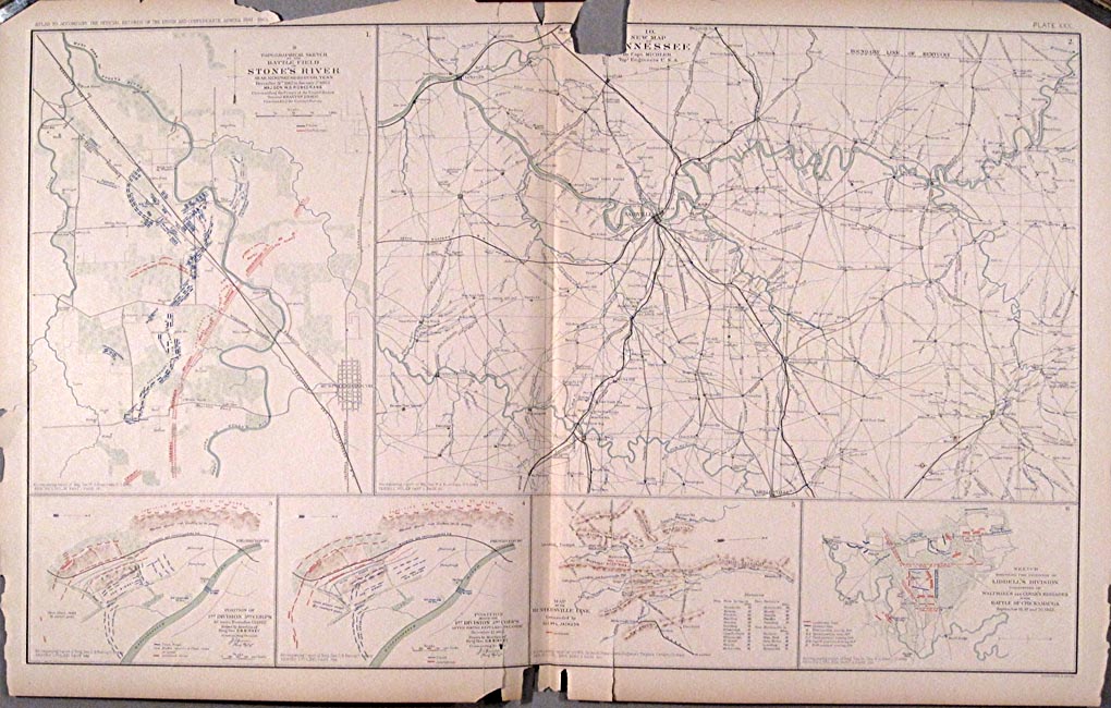
- 30. Battle-Field of Stone's River, December 31st, 1862 to January 3rd, 1863, Major Gen. W.S. Rosecrans commanding the Forces of the United States / New map of Tennessee by Capt. Michler plus 4 smaller maps. With chips in margins and at top into image. $75
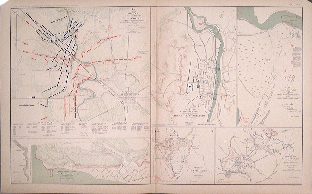
- 31. Battle of Murfreesborough, December 30th to January 3rd, 1863 / Stone's River Campaign, January, 1863 / Battle before Murfreesborough. Tenn., December 31st, 1862 / Battle of Fredericksburg, Saturday, December 13th, 1862 / Fortifications and environs of Tullahoma / Battle-Field of Thompson's Hill, (Port Gibson), May 1, 1863. With tear along center fold from top to 1/3 down. $75
- 32. Battles of Stone's River before Murfreesborough, December 31st, 1862, January 1,2,3 1863 / Battle of Fredericksburg, December 13th, 1862 / Sabine Pass plus 3 maps. $60
- 33. Fredericksburg prepared by Bvt. Brig. Gen. Michler, 1867 / Sioux Expedition, 1863 plus 4 smaller maps. $60
- 34. Vicinity of Readyville, Tenn., Bradyville, Tenn., and Woodbury, Tenn., June 26th, 1863 / Shelbyville, Tenn. and vicinity, June 10th, 1863 plus 3 quick maps. $60
- 35. Vicinity of Decherd / Manchester and Vicinity / Sketch of Tullahoma, Tenn. and Vicinity / Proposed Road along South Bank of New Canal from Duckport to Walnut Bayou / Jasper and Vicinity / Chattanooga and Vicinity / Shelbyville and Vicinity - July 1863. $125
- 37. Defenses of Vicksburg, Miss., surveyed February, 1863 / Jackson and vicinity, May 14th to 16th and July 10th to 21st, 1863 / Jackson and vicinity, July 20th, 1863 / Vicksburg and vicinity / Jackson, Miss., 9th to 17th, July, 1863 / Big Black River Railroad Bridge and vicinity, May 17th, 1863 / Battle-field of Big Black River Bridge, May 17th, 1863. $60
- 38. Galveston, Tex. And its Fortifications / Port Hudson, La. And vicinity, 1864 / Siege Operations against the Defenses of Charleston Harbor, 1863. $150
- 39. Operations at Jackson, Miss. compiled from surveys May 14th to 16th and survey since July 10th, 1863 / Rappahannock River, April and May, 1863 / Field-Operations of the Army of the Potomac between April 27th and May 7th, 1863 / Portions of the Middle Department, 2nd Division, Winchester, June, 1863. $75
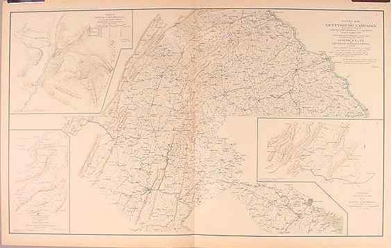
- 42. Military map of Harper's Ferry, Va. surveyed from August 3rd to September 30th, 1863 / Vicinity of Hagerstown, Funkstown, Williamsport and Falling Waters, Md. accompanying Report on the Battle of Gettysburg dated October 1st, 1863 plus 3 smaller maps. $75
- 44. Siege Operations against the Defenses of Charleston Harbor prior to July 18th, 1863 / Plate III Sections of Approaches / Sketch of Operations of the Army of the Potomac from November 26th to December 3, 1863 / Siege Operations against the Defenses of Charleston Harbor prior to capture of Fort Wagner, September 7, 1863. $75
- 45. Orange County & c., Va. / Military Departments of Washington, Pennsylvania, Annapolis and Northeastern Virginia, July, 1861 / Second Army Corps and The Enemy, October 14, 1863 / Battle-Field at Bristoe, October 14, 1863 / Missionary Ridge, Tenn., November 24th and 25th, 1863 plus 3 smaller maps. $60
- 46. Battle-Field at Chickamauga, September 19th, 1863 (sheet No.1) / Battle-Field of Chickamauga, September 20th, 1863 (sheet No.2) / Turkeytown Valley, Ala., October 24-26, 1864 / Battle of Chickamauga, September 19 and 20, 1863. $75
- 47. Army of Missouri, September, October, November, 1864 / Battle of Chickamauga, September 19th, 1863 / Battle of Chickamauga, September 19th, 1863 / Battle of Chickamauga at midnight September 18th, 1863 / Engagement at Wauhatchie, Tenn., October 28th and 29th, 1863 plus 3 smaller maps. $60
- 48. The Chickamauga Campaign, August 16-September 22, 1863 / Knoxville, E. Tenn. surveyed during December, January and February 1863-64 plus 3 smaller maps. $75
- 49. Battle-Field at Chattanooga, 1864 / Map accompanying report of Major Gen. Howard plus 3 smaller maps. $100
- 50. County in Vicinity of Brown's Ferry / Battle-Field at Missionary Ridge, November 23,24 and 25, 1863 / Positions of Second Division, Fourth Army Corps, Chattanooga, Tenn., November 23 to 25, 1863 / Battle of Lookout Mountain, Tenn., November 24, 1863 plus 2 smaller maps. $75
- 51. Country between Vicksburg and Meridian, Miss., February, 1864 / Sketch of City of Atlanta and Line of Defenses / Sketch of Battery / Smith's Island, N.C., November, 1863. $75
- 52. Valley of the Red River, La. from Mississippi River to Shreveport, spring 1864. $60
- 53. Parts of Arkansas and Louisiana, 1864 / Section including Falls and Dam in Red River / Battle-Field of Ocean Pond, Fla., February 20th, 1864 / Part of La., January, 1864. $60
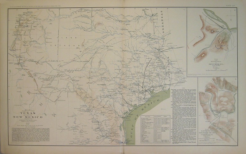
- 54. Texas and part of New Mexico, 1857 / Battle-Field at New Creek, W.Va., August 4th, 1864 / Battle-Field at Pleasant Mills, August 1st, 1864. NA
- 55. Battle-Field of The Wilderness, Va., May 5th,6th and 7th, 1864 / Battle-Field of Spotsylvania C.H., Va. From May 8th to 21st, 1864 / Todd's Tavern, Va., May 8th, 1864 / Battle-Fields of North Anna from May 3rd to 27th, 1864 / Battle-Fields of Totopotomoy and Bethesda Church, Va. From May 28th to June 2nd, 1864 / Positions of the Army of the Ohio, Dalton, Ga., May 8th and 9th, 1864. $100
- 56. Vicinity of Petersburg, Va., 1862 / Atlanta Campaign from June 15th to July 3rd, 1864 / Atlanta Campaign from July 5th to 18th, 1864 / Army of the Tennessee from May 27th to June 4th, 1864 / Battle Ground of the Army of the Tennessee July 22nd, 1864 / Battle Ground of the Army of the Tennessee, July 28th, 1864 / Atlanta Campaign Operations from July 18th to 27th, 1864. $75
- 57. Operations of the Army under the command of General W.T. Sherman in Georgia from May the 5th to September the 4th, 1864 / First Epoch of the Atlanta Campaign / Roads followed by the Army of the Tennessee in its march from Chattanooga, Tenn. To Atlanta, Ga. $100
- 58. Second Epoch of the Atlanta Campaign / March of the 15th Army Corps through Northern Georgia, 1864 / Kenesaw Mountain, Ga. From June 10th to July 3rd, 1864 plus 3 smaller maps. $100
- 59. Third Epoch of the Atlanta Campaign with 8 maps showing positions of armies. $100
- 61. Battle of Bethel, Va., June 10th, 1861 / March of Left Wing, 16th Army Corps from April 29th to May 4th, 1864, / Siege of Blakely, Ala. invested April 24th, 1865 plus 12 maps showing positions. $60
- 62. March of the Left Wing 16th Army Corps from May 5th to September 8th, 1864 / Battle-Field occupied by General Blair, 17th Army Corps, July 5th to 11th, 1864 on the Chattahoochee plus 12 maps showing positions. $60
- 63. "A" Plan of Siege Operations against Fort Morgan, Ala., August, 1864 / Battle-Field at Harrisburg, Miss. fought July 14th, 1864 / Defense of Fort Morgan, August, 1864 / Entrance of Mobile Bay, August, 1864 / Battle of Fredericksburg, Va., December 13, 1862 / Battle-Field of Mechanicsville and Cold Harbor, Va. plus 3 smaller maps. NA
- 64. Engineer Department (appendix 65) Headquarters Army of the Potomac, July 28th, 1864 / Part of the line of the U.S. Forces (appendix 66), July 29th, 1864 / Positions and Operations of the Artillery, Army of the Potomac, July 30th, 1864 / Reconnaissance beyond the Chickahominy at Bottom's and Railroad Bridges, May 21st, 1862. $60
- 65. Road between Bermuda Hundred and Enemy's First Line of Intrenchments, June, 1864 / Road from pontoon-bridge at Point of Rocks to Petersburg / Coast of Texas and its defenses, 1864 with inset of forts plus 7 smaller maps. $150
- 66. Campaign against Sterling Price, 1864 / West Point and Big Blue, Mo. / West Point and Big Blue, October 22nd and 23rd, 1864 / Battle-Field of Five Forks, Va., April 1st, 1865 and field of operations / Battle-Field of Five Forks, Va., April 1st, 1865 showing positions and movements / Military Prison on Johnson's Island, Ohio plus 7 smaller maps. $60
- 67. Federal Point, N.C. / Fort Pemberton near Greenwood, Miss. / Country and vicinity of New Berne, N.C., May, 1864 / Defensive works at Harrison's Landing, September 21st, 1864 / Deep Bottom, Va., October 26th, 1864 / Weldon Railroad / Positions in front of Petersburg, Va., September 13th, 1864 / Lookout at Crow's Nest near Bermuda Hundred, Va. and 2 smaller maps. $60
- 68. Defensive lines 18th Army Corps from Fort Brady to Fort Burnham, October, 1864 / Defensive lines 10th Army Corps from Fort Burnham to right of New Market Road, October, 1864 / Battle-Field of Five Forks, Va., Saturday, April 1st, 1865 / Casement in Fort Burnham, January, 1865 plus 5 smaller maps. $75
- 69. Upper Potomac from McCoy's Ferry to Conrad's Ferry and portions of Maryland and Virginia, October, 1865 / Second map of the region with additional drawings, October, 1865 / Battle-Field of Cedar Creek, Va., October 19th, 1864 / March routes of the Army of the Tennessee from Atlanta to Savannah, Ga. / Position of the 15th Army Corps in front of Savannah, Ga., December, 1864. $60
- 71. Campaign maps (Numbers 1 to 11 inclusive) Atlanta, Ga. to Savannah, Ga., December, 1864 / Blakely, Ala., April 9, 1865 / Expedition from Messinger's Ferry toward Canton, Miss., October 14-20, 1863 / Defenses of the City of Mobile plus 1 small map. $60
- 72. Battle-Field in front of Franklin, Tenn., November 30th, 1864 / Battle-Field in front of Nashville, Tenn., November 15th and 16th, 1864 / Battle-Field in front of Waynesborough, Va., March 2nd, 1865 / Battle-Field in front of Waynesborough, Va. (more detailed) plus 3 smaller maps. $75
- 73. Battle-Field of Nashville, Tenn., 15th and 16th December, 1864 / Battle-Field of Nashville, Tenn. showing the positions of Stewart's Corps, December 15th and 16th, 1864 / Battle-Field of Franklin, Tenn. plus 3 smaller maps. $75
- 74. Central Virginia showing Major Gen. Sheridan's Campaigns, 1864-1865 / Battle-Field of Dinwiddie C.H., March 31st, 1865 plus 3 smaller maps. $75
- 75. Sketch of vicinity of Fort Fisher with inset / Plan of Fort Fisher, January 15, 1865 / Plan of final attack on Fort Fisher, January 15th, 1865. $100
- 76. Battle-Ground at Rivers' Bridge, Big Salkehatchie River, S.C. / Chart of Cape Fear River and Port of Wilmington, N.C. / Operations of the Army of the Potomac from March 29th to April 9th, 1865 / Pile Bridge, James River near Varina, Va., January, 1865 plus 2 smaller maps. $60
- 77. Richmond, Va., 1867 / Bermuda Hundred, Va., 1867 / Petersburg and Five Forks, Va., 1867 / Jetersville and Sailor's Creek, Va., 1867. $75
- 78. Routes from Petersburg, Chester Station and Manchester to Amelia Court-House, Va. / Appomattox Court-House, Va., 1867 / Roads to Corinth, Miss. / High Bridge and Farmville, Va., 1867 / Petersburg Mine Explosion, July 30, 1864 / Pittsburgh, Tenn., March 24th, 1862. [stains] $60
- 79. Environs of Petersburg, Va. from Appomattox River to Fort Howard / Position of the Army of the Tennessee during the Battle of Bentonville, N.C., March 20th and 21st, 1865 / Routes of the Army of the Tennessee during the winter campaign in the Carolinas (2 sections) / Engagement near Bentonville, N.C. / Battle-Field of Pea Ridge, Ark., 8th of March, 1862 / Siege operations at Spanish Fort, Mobile Bay. [stains] $45
- 80. Campaign maps (1 to 11 inclusive) exhibiting the line of march of the 20th Corps from Savannah, Ga. to Goldsborough, N.C., 1865 / Battle of Black River, N.C., March 16th, 1865. $65
- 81. Battles of the Wilderness and Spotsylvania C.H., Va., May 1864 / Army of the Valley Dist. From Staunton, Va. to Washington, D.C. and back to Strasburg, Va., from June 27th to July 22nd, 1864 / 2nd Corps, A.N. Va. from May 21st to 27th, 1864 / 2nd Corps, A.N. Va. from Gaines' Mill to Lynchburg, Va., June 13th to 18th, 1864 / 2nd Corps, A.N. Va. from May 27th to June 13th, 1864 / 2nd Corps, A.N. Va. at Hanover Junction, Va., May 22nd to 27th, 1864 plus 1 small map. $45
- 82. Engagement at Harper's Ferry, Va., July 4th, 1864 / Battle of Belle Grove or Cedar Creek, Wednesday, October 19th, 1864 plus 10 smaller maps. [stains] $45
- 83. Battle of the Wilderness, Thursday, May 5th, 1864 / Battle of the Wilderness, Friday, May 6th, 1864 / North Mountain Depot, Va. Monday, July 4th, 1864 / Battle of Rutherford's Farm, Va., July 20th, 1864 / Engagement near Lynchburg, Va., Saturday, June 18th, 1864 / Engagement at Hanging Rock, Roanoke County, Va., Tuesday, June 21st, 1864 / McCausland's Calvary Brigade at Hagerstown, Md., Thursday, July 7th, 1864 / Battles of Spotsylvania C.H., Va. from May 9th to 21st, 1864 / Battle of Monocacy, Frederick County, Md., Saturday, July 9th, 1864. NA
- 84. Engagement at Milford, Va., Wednesday, September 21st, 1864 / Action near Brock's Gap, Va., October 6th, 1864 / Lacey Spring, Va., Wednesday, December 21st, 1864 / Action at Liberty Mills, Va., Friday, December 23rd, 1864 / Routes of Rosser's Division to Beverly, Va. and back, January 7th to January 18th, 1865 / Rude's Hill, Va., Tuesday, March 7th, 1865 / Liberty Mills, Va., Friday, December 23rd, 1864 / Moorefield, Va., Sunday, November 27th, 1864 / Gordonsville, Va., December 24th, 1864 / Camps and Pickets of the Army of the Valley District, January 31st, 1865 / New Creek and Vicinity, Monday, November 28th, 1864 / Capture of Beverly, Va., January 11th, 1865 plus 24 small maps which accompanied the journal of Capt. Jed Hotchkiss. [stains/tears] $45
- 85. Battle of Winchester, May 25th, 1862 and the Pursuit of the Enemy / Sketch of the Battle of Winchester, Va., Sunday, May 25th, 1862 / Battles of Port Republic, Va., June 8th and 9th, 1862 / Battle of Cedar Run, Va., 1863 / Battle of Cedar Run, Va., Saturday, August 9th, 1862 plus 35 sketches accompanying journal of Capt. Jed Hotchkiss. $100
- 86. Campaign from Savannah, Ga. to Goldsborough, N.C. (maps. 1 to 7 inclusive) / Campaign from Goldsborough, N.C. to Washington, D.C. (maps 8 to 16 inclusive) / Operations about Bottom's Bridge, Va., May 20-23, 1862. [Old tears repaired with scotch tape] $45
- 87. Vicinity of Mine Run in Orange County, Va., 30th of November, 1863 / Picket Line of the First and Third Cavalry Divisions, Cavalry Corps, Army of the Potomac / Position of the Army of Northern Virginia, April 13, 1864 / Camp near Brandy Station, Va.. plus 2 smaller maps. [Marginal tears repaired with archival tape] $45
- 88. Siege of Atlanta, Ga. in the United States Forces under command of Major Gen. W.T. Sherman from the passage of Peach Tree Creek, July 19th, 1864 / Operations of the Army under the command of Major Gen. W.T. Sherman in Georgia from May 5th, 1864 to September 4th, 1864. [Old tears repaired with scotch tape] $60
- 90. Approaches to New Orleans, February 14th, 1863 / Positions occupied by the 4th Division , 17th Army Corps. during Battle of Atlanta, Ga., July 22nd, 1864 plus 9 small maps. $60
- 91. Spotsylvania County, 1863 / Vicinity of Hanover Junction, Va. and its Defenses with 3 insets plus 3 smaller maps. $60
- 92. Vicinity of Richmond, Va. and part of the Peninsula, 1864 plus 3 smaller maps. $100
- 93. Preliminary map of a part of the South Side of James River, Va., 1864 / Battle-Field of Chancellorsville, Va., 1867. $100
- 94. Line of Defenses in the Alleghanies / Valley of Virginia from Staunton to Winchester plus 6 smaller maps. $100
- 96. Battle-Field of The Wilderness, Va., 1867 / Battle-Field of North Anna, Va., 1867 / Battle-Field of Spotsylvania Court-House, Va., 1867 / Battle-Field of Totopotomoy, Va., 1867 plus 2 smaller maps. NA
- 97. Army movements around Chattanooga, Tenn., January 4th, 1864 / Battle-Field of Cold Harbor, Va., 1867 / Battle-Field of Chickamauga, Ga. surveyed by command of Major Gen. G.H. Thomas, April and May, 1864. $100
- 99. Battle-Field of Winchester, Va., September 19th, 1864 / Battle-Fields of Fisher's Hill and Cedar Creek, Virginia, 22nd September - 19th October, 1864. [Chips in margins; short tear in margin repaired with archival tape, none affecting image] NA
- 100. Central Virginia showing Lieut. Gen. U.S. Grant's Campaign and Marches of the Armies under his Command in 1864-1865 / No.12 Region embraced in the operations and of the Armies against Richmond and Petersburg, Va., 1865. $125
- 101. Campaign maps showing position of the 20th Army Corps on the march from Chattanooga, Tenn., to Atlanta, Ga. with dates and Union and Rebel Defenses (maps 1 to 19 inclusive) / Battle-Field of Peach Tree Creek, Ga., Fought, July 20th, 1864 / March of the Army under command of Major Gen. W.T. Sherman from Atlanta, Ga. to Savannah, Ga., November 15th to December 21st, 1864. NA
- 102. Defenses of Munfordville, Ky., 1863 / Defenses of Camp Nelson, Ky., August, 1864 / Louisville and its Defenses. $100
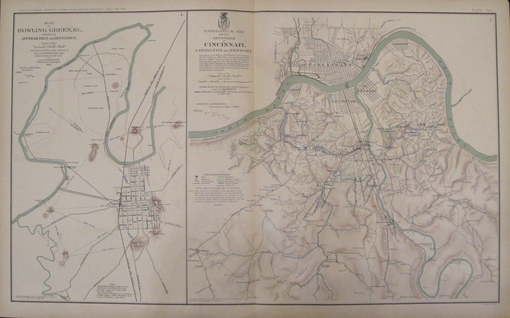
- 103. Bowling Green, Ky., showing its Approaches and Defenses, 1863 / Defenses of Cincinnati, Covington and Newport, 1864. $100
- 104. Twelve maps of Petersburg, Va. showing Batteries and Siege, 1864. $60
- 105. Rebel Defenses Mobile, Ala., April 12th, 1865 plus 8 smaller maps. $75
- 106. Drawings of Canvas Pontoon Boats, Bridges and Chess Wagons / Drawings of Rifle Projectiles used by the Rebels in the Virginia Campaign of 1864. $45
- 107. Four maps of Siege of Petersburg, Va., July, 1864 / Drawings of Rifle Projectiles in the Virginia Campaign of 1864 / Mobile Defenses, Fort Sidney Johnston, N. / Mobile Defenses, Battery McIntosh, water battery / Mobile Defenses, Redan Nos. 7 and 8. $45
- 108. Rebel lines, Mobile Defenses, Fort Jeb Stuart K, Fort Mouton, Lunette D and Fort G, H and I. $45
- 109. Rebel lines, Mobile Defenses, Forts E and F, Redan No. 1,2,3,4,5, and 6. $45
- 110. Campaign of the Army of West Mississippi, Major Gen. E.R.S. Canby, Com.in Southern Alabama, March and April, 1865. [tears] $125
- 111. Battle-Field of Chickamauga, Ga., and vicinity fought September 18th,19th and 20th, 1863 / Positions of the 2nd Corps, A.N. Va.., August 26th to September 2, 1862 / Defenses of Chattanooga, Tenn. plus 12 smaller maps. $60
- 112. Bridgeport, Ala. / Stevenson, Ala. / Sketch of Fortress Rosecrans near Murfreesborough, Tenn., April, 1865 / Defenses of Nashville, Tenn. plus 4 smaller maps. $100
- 113. Two maps showing Defenses of Chattanooga, Tenn., Battery Erwin and Battery Coolidge / Seven maps showing Defenses of Nashville, Tenn., Battery for Casino Hill, Fort Morton, Capitol, Fort Sill, Fort Dan McCook, Fort W.D. Whipple and Redoubt for Hill No. 210. $45
- 114. Defenses of Nashville, Tenn., Fort at Hyde's Ferry, 1865 / Defenses of Nashville, Tenn., December 1st, 1865 / Fort Donelson, Tenn. / Defenses of Nashville, Tenn., Fort Harker, 1865 / Memphis and its Environs / Fort Pickering, Memphis, Tenn. $60.
- 115. Johnsonville, Tenn. / Clarksville, Tenn., May, 1865 / Franklin, Tenn. / Columbia, Tenn., and vicinity / Gallatin, Tenn. / Dalton, Ga. / Huntsville, Ala. plus 2 smaller maps. $60
- 116. Battle of McDowell, Va. on Thursday, May 8th, 1862 / Pocahontas and Highland Co. W.Va., April 15th-22, 1865 / Route Map of Gettysburg Campaign and used during that campaign by General R.E. Lee, January to April, 1863 / Route to McDowell. NA
- 117. Military map of the Marches of the United State Forces under command of Major Gen. W.T. Sherman during the years 1863, 1864 and 1865. $100
- 118. Army of the Cumberland / Cumberland Gap, Tenn. during a portion of the year 1862 / Environs of Petersburg, Va. $100
- 120. Army of the Tennessee from Savannah, Ga. to Columbia, S.C., 1865 / Territory and Military Department of Utah, 1860. $100
- 121. Nine photographic views of Forts Sumter and Moultrie, Charleston, S.C., April, 1861. [Old tears repaired with scotch tape] $100
- 122. Eleven photographic views of Forts Sumter and Moultrie and Battery Beauregard, Charleston, S.C., 1864. [Old tears repaired with scotch tape] $100
- 123. Photographic panoramic view of Chatttanooga, Tenn. from Cameron Hill. taken April, 1864. Seven photographic views of and vicinity of Chattanooga, Missionary Ridge and The Suck-Tennessee River. [Old tears repaired with scotch tape] $100
- 124. Nine photographic views of Nashville, Tenn., Roseville Gap, Ga., Battery, Intrenchments at Dutch Gap, Va., Canvas Pontoon Bridge, Appomattox River, Broadway, Va., Fort on St. Cloud Hill, Nashville, Tenn., Buzzard Roost Gap and Rocky Face Ridge, Ga., Battery Spofford, Va., Point of Lookout Mountain, Tenn. and Signal Station, Va. [Old tears repaired with scotch tape] $100
- 125. Eight photographic views of Batteries and Redoubts in Va.. Three photographic views of Castle Thunder, Richmond, Va., May, 1865, Dutch Gap, Canal, as finished April, 1865 and Pontoon Bridge on the James River. $100
- 126. Photographic views of and vicinity of the Capitol, Richmond, Va. taken May, 1865, Libby Prison (north side and south side) taken May, 1865 and Post Hospital, City Point, Va., 1865. Seven views of Federal Forts. [Old tears repaired with scotch tape] $100
- 127. Six photographic views of Federal Forts, Atlanta, Ga.. Four views of Rebel Forts, Atlanta, Ga.. Two views of Rebel Batteries, Atlanta Ga.. $100
- 128. Twelve photographic views of Rebel Lines in the vicinity of Atlanta, Ga.. $100
- 129. Four photographic views of Rebel Lines in Atlanta, Ga.. Views of U.S. Rolling Mill at Chattanooga, Tenn., Ruins of Rolling Mill and Cars, Round-House, Chattanooga R.R., at Atlanta, Ga., Potter House, Ga. and Engine "Hero". Panoramic view of Position of Iron Clads, January 15th, 1865. $125
- 130. Four panoramic views of Knoxville, Tenn.. Two views of Chattanooga, Tenn. [Old tears repaired with scotch tape] $100
- 132. Parts of Brunswick and New Hanover Counties showing the approaches to Wilmington, N.C. / Fort Caswell and adjoining works at Western Bar Cape Fear River, N.C., evacuated January 16th, 1865 / Line of Rebel Works, Smith's Island, N.C., evacuated January 16th, 1865 / Defenses of Augusta, Ga. / Fort Johnston, Smithville, N.C. evacuated January 16th, 1865 / Battle-Field of Champion's Hill, Miss., May 16th, 1863 plus 2 smaller maps. $60
- 133. Battle of Averasborough, N.C. fought March 16th, 1865 / Savannah, Ga. / Battle of Bentonville, N.C. fought March 19th, 1865 / Bird's Point, Mo. from surveys in the Summer of 1861. $60
- 134. "Essayons" Topographical Map of California, Nevada, Oregon and part of Idaho, 1867. [Old tears repaired with scotch tape] $100
- 135. Battle-Field of Wilson's Creek, Mo., August 10, 1861 / Battle of Cedar Mountain, Va. fought August 9th, 1862 / Section of Buckingham and Appomattox Counties, Va., December 25th, 1863 / Section of Hanover, Henrico and part of Chesterfield Counties, Va., 1864 / Defenses of Macon, Ga., 1864 / Battle-Field of Chancellorville, Va., May 1 to 5. [Old tears repaired with scotch tape] $75
- 135-A Section of New Guide Map of the United States and Canada with Railroads, Counties etc., 1863. $125
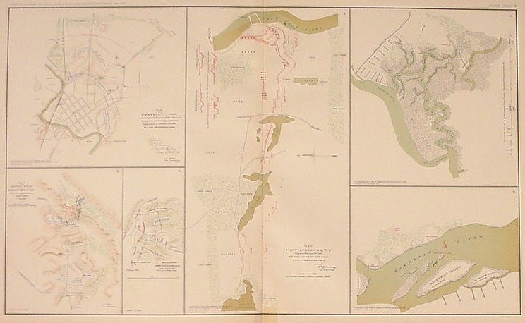
- 135-B Franklin, Tenn., November 30th, 1864 / Battle-Field of Droop Mountain / Battle Ground near White Sulphur Springs, August 26 and 27, 1863 / Fort Anderson, N.C. captured February 19th, 1865 by the Army of the Ohio plus 2 smaller maps. $60
- 135-C Part of Virginia exhibiting the routes of Gen. W.W. Averell, August, November & December, 1863 / Vicinity of New Creek Sta. B. & O. R.R., August, 1863 / Battle-Field of Baker's Creek, May 16th, 1863 / Tete de Pont and Battle of Big Black Bridge, May 17th, 1863 / Field works at Franklin, Tenn., November 30th, 1864. $60
- 136. General topographical map. Sheet I. Sections of Pennsylvania, Maryland, West Virginia, Virginia, New Jersey and Delaware. Chipes in left and right margins, not affecting image. $125
- 137. General topographical map. Sheet II. Sections of West Virginia, Virginia, Maryland and Delaware. $125
- 138. General topographical map. Sheet III. Sections of Virginia, North Carolina and small inset of South Carolina. $125
- 139. General topographical map. Sheet IV. Sections of North Carolina and South Carolina with an additional map of Entrances to Cape Fear River, North Carolina. $100
- 140. General topographical map. Sheet V. Sections of Ohio, Pennsylvania, Kentucky, West Virginia and small sections of Virginia and Maryland. $75
- 141. General topographical map. Sheet VI. Sections of Ohio, West Virginia, Kentucky and Virginia. Bottom corners chipped, outside printed area. $75
- 142. General topographical map. Sheet VII. Sections of Kentucky, Tennessee, Virginia, North Carolina, South Carolina and Georgia. $100
- 143. General topographical map. Sheet VIII. Sections of Georgia and South Carolina with a small section of North Carolina. $100
- 144. General topographical map. Sheet IX. Sections of South Carolina and Georgia. $125
- 145. General topographical map. Sheet X. Sections of Georgia and Florida. $100
- 146. General topographical map. Sheet XI. Sections of Florida shown in two maps. $100
- 147. General topographical map. Sheet XII. Sections of Mississippi, Alabama, Georgia and Florida. $100
- 148. General topographical map. Sheet XIII. Sections of Mississippi, Alabama and Georgia. $75
- 149. General topographical map. Sheet XIV. Sections of Tennessee, Mississippi, Alabama, Georgia and a small section of North Carolina. $100
- 150. General topographical map. Sheet XV. Sections of Illinois, Indiana, Kentucky and Tennessee. $100
- 151. General topographical map. Sheet XVI. Sections of Illinois, Indiana, Kentucky and Ohio. $100
- 152. General topographical map. Sheet XVII. Sections of Missouri and Illinois. $100
- 153. General topographical map. Sheet XVIII. Sections of Missouri, Illinois, Kentucky, Arkansas and Tennessee. $75
- 154. General topographical map. Sheet XIX. Sections of Arkansas, Tennessee and Mississippi. $100
- 155. General topographical map. Sheet XX. Sections of Louisiana, Arkansas and Mississippi. $100
- 156. General topographical map. Sheet XXI. Sections of Louisiana and Mississippi. $125
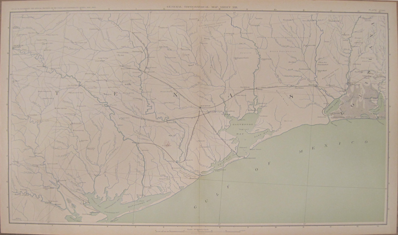
- 157. General topographical map. Sheet XXII. Sections of Texas and Louisiana. $225
- 158. General topographical map. Sheet XXIII. Sections of Texas, Arkansas and Louisiana. $185
- 159. General topographical map. Sheet XXIV. Sections of Indian Territory, Texas and Arkansas. $100
- 160. General topographical map. Sheet XXV. Sections of Kansas, Indian Territory with tribes mentioned, Missouri and Arkansas. $100
- 161. General topographical map. Sheet XXVI. Sections of Kansas with reserves indicated and Missouri. $125
- 163. The United State of America showing the Boundaries of the Union and Confederate Geographical Divisions and Departments, June 30, 1861. [Old tears repaired with scotch tape] $125
- 164. The United States of America showing the Boundaries of the Union and Confederate Geographical Divisions and Departments, December 31, 1861. [Old tears repaired with scotch tape] $125
- 165. The United States of America showing the Boundaries of the Union and Confederate Geographical Divisions and Departments, June 30, 1862. [Old tears repaired with scotch tape] $125
- 166. The United States of America showing the Boundaries of the Union and Confederate Geographical Divisions and Departments, December 31, 1862. [Old tears repaired with scotch tape] $125
- 167. The United States of America showing the Boundaries of the Union and Confederate Geographical Divisions and Departments, June 30, 1863. [Old tears repaired with scotch tape] $125
- 168. The United States of America showing the Boundaries of the Union and Confederate Geographical Divisions and Departments, December 31, 1863. [Old tears repaired with scotch tape] $125
- 169. The United States of America showing the Boundaries of the Union and Confederate Geographical Divisions and Departments, June 30, 1864. [Old tears repaired with scotch tape] $125
- 170. The United States of America showing the Boundaries of the Union and Confederate Geographical Divisions and Departments, December 31, 1864. [Old tears repaired with scotch tape] $125
- 171. The United States of America showing the Boundaries of the Union and Confederate Geographical Divisions and Departments, April 9, 1865. [Old tears repaired with scotch tape] $125
- 173. Drawings of Guns, Model 1861, Field Carriage, Battery Wagon, Mountain Artillery, Barbette Carriages (wood and iron), Casement Carriage (wood and iron), Caisson, Siege Carriage, Carriage for Flank Casemates's (wood), Horse Equipment, Traveling Forge, Mortar Wagon, Revolvers and Rifles. [Old tears repaired with scotch tape] $45
- 174. Diagrams illustrating the Principal Means used in Transporting the Sick and Wounded and Medical Supplies during the War of the Rebellion, 1861-5 No.1-38. [Old tears repaired with scotch tape] $45
- 175. U.S. and Confederate Flags and Badges in color with additional notes. [Old tears repaired with scotch tape] NA
 Return to Civil War maps page
 Go to Civil War home page


For further information, please contact:


106 E. Lancaster Avenue, Lower Level
Wayne, PA 19087 USA
610.808.6165
PhilaPrint@PhilaPrintShop.com 
©The Philadelphia Print Shop Last updated July 15, 2021
