|
|
 |
|
|
|
|


![]()
Alvin J. Johnson began publishing his New Illustrated Family Atlas in 1860 and continued to publish it through the Civil War years to 1865. Included in these atlases was a series of double page maps. This map shows detail of Civil War activity in Virginia from its tidewater region in the East, to Richmond in the West. Excellent detail of the three rivers mentioned in the title, as well as railroads, main roads and the Union Army's route of advance from Yorktown to Fair Oaks, then retreat via Charles City CH and advance to Malvern Hills, whence a retreat was then made to Harrison's Pt. & Landing. $275

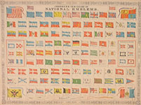
"Johnson's New Chart of National Emblems." [Flags of the World]. Stone lithography (hand colored). New York: Johnson & Ward, 1863. 16 7/8 x 23 1/8. Center fold as issued. Slight browning. A few chips around the edges, else fine and bright.
Alvin J. Johnson began publishing his New Illustrated Family Atlas in 1860 and continued to publish it through the Civil War years and through to 1885. Many issues contained a double page such as this one illustrating flags of the world. The 1863 issue was one of the few which illustrated the flag of the Confederate States of America [top of bottom right quadrant] at a time when the Northern States did not recognize the Southern confederacy. Indeed, publishing sympathetic writings or pictures could be treasonous, thus a warning that this government was "so called"; is added to the description. Perhaps this phrase saved the publisher from a charge of sedition, but it also showed how Confederate warships and especially raiders were on the minds of the Northern public. The other flags reflect developments in various parts of the World. $195

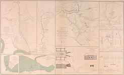
Plate 68. "Defensive lines 18th Army Corps from Fort Brady to Fort Burnham, October, 1864 / Defensive lines 10th Army Corps from Fort Burnham to right of New Market Road, October, 1864 / Battle-Field of Five Forks, Va., Saturday, April 1st, 1865 / Casement in Fort Burnham, January, 1865 plus 5 smaller maps.." Maps from the U.S. War Department's Atlas to Accompany the Official Records of the Union and Confederate Armies. Washington: Gov't. Printing Office, 1891-95. Lithographed map, with some highlight color. Double folio size. Very good condition.
Richard Stephenson has written, "This is the most detailed atlas yet published on the Civil War. It consists of reproductions of maps compiled by both Union and Confederate soldiers." [Stephenson, Civil War Maps, p 99.] The maps show many of the events of the Civil War with great detail, including topography, troop placements and movements, and other information of interest. These are the best near contemporary maps available of many of these battles, sieges, and other events of this conflict. $75
![]() Go to complete listing of Civil War Battle Maps
Go to complete listing of Civil War Battle Maps
![]()
For further information, please contact:

![]()
106 E. Lancaster Avenue, Lower Level
Wayne, PA 19087 USA
610.808.6165
PhilaPrint@PhilaPrintShop.com ![]()
©The Philadelphia Print Shop Last updated July 15, 2021