|
|
|
|
|
|
|

![]()

Perhaps the most famous map of Philadelphia, the Scull & Heap map went through many editions beginning in 1752. As much of the intent of this publication was to promote the city and its surrounding regions, the map was made available for printing in a popular periodical, Gentleman's Magazine, where it appeared the next year in a reduced size. As the first edition, separately issued in Philadelphia, is extremely scarce, the Gentleman's Magazine edition is the first generally available version of this important map.
The Holme grid plan for the city lies at the center of the map, with an open Centre Square and the Court House the only indicated features. More information is given about the surrounding regions, where roads, mills, and houses of prominent citizens are shown and named. These details give us a wealth of information about the development of the Philadelphia area in its nascent days. Especially interesting is a considerably developed Germantown, with houses lining both sides of Germantown Pike, and a table of distances from the Court House is in the lower right corner, the latter only appearing in this first edition.
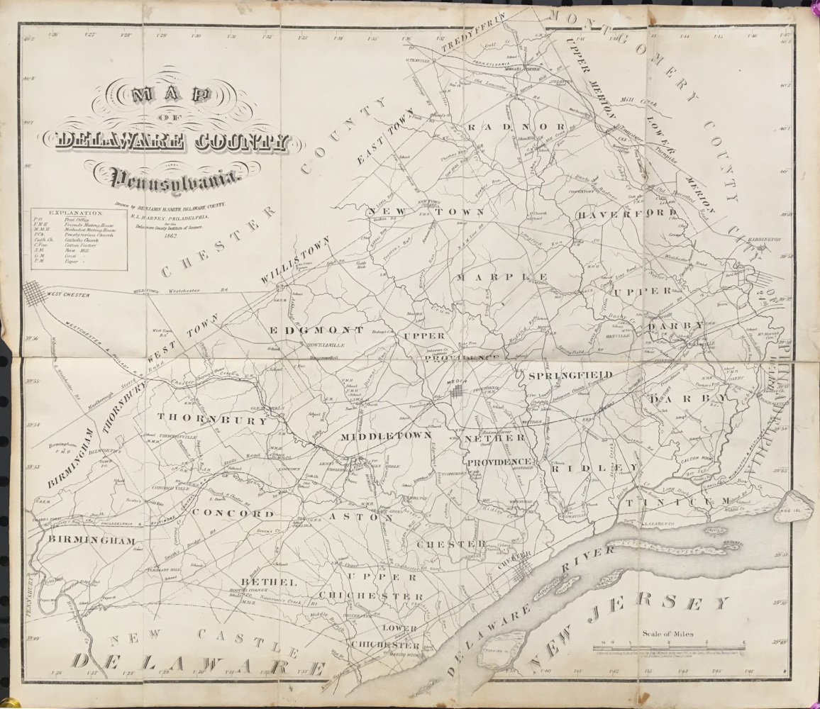
Benjamin H. Smith. "Map of Delaware County, Pennsylvania." Philadelphia: R.L. Barnes, 1862. For Delaware County Institute of Science. 17 3/4 x 20. Lithograph. Uncolored. Folding map dissected into 10 sections and mounted onto linen backing as originally issued. Minor staining in margins not affecting image. Else, very good condition. $400
A map that was included in the book, History of Delaware County, published in 1862. This fine and detailed map was issued at the time of the Civil War and depicts roads, rail lines, churches, post offices and other businesses in the county.
Starting around 1870, atlases of properties within and outside of Philadelphia began to be published by such firms as Bromley, Hopkins and Mueller. Their output has provided us with excellent, detailed images of the growth of the city of Philadelphia and the suburbs as well from the 1870s through the first part of the twentieth century. These atlases were used for planning, government purposes, and just for the information of citizens of the area. These atlases are also known as 'railroad, real estate, and/or insurance' atlases and contained very accurate and detailed information such as streets, properties, parks, and other topographical and social features.
We have many maps from the following areas: The City of Philadelphia; Montgomery County and townships; Delaware County and townships; Chester County and townships; Bucks County and townships. Please call or email for more information.

"Radnor." Philadelphia: G. M. Hopkins, 1870. From Atlas of Philadelphia and Environs. 16 1/2 x 13 1/4 (image). Lithograph. Original hand color. Very good condition. Framed. $300

Plate 10. [Bryn Mawr, PA]. From Atlas of Lower Merion Township. Philadelphia: A. H. Mueller, 1895. Lithograph. Original hand color. Double folio. 20 1/2 x 30 3/4. $350

Plate 12. [Bryn Mawr, PA]. From Pennsylvania Railroad Atlas of the Main Line from Overbrook to Paoli. Philadelphia: A. H. Mueller, 1908. Lithograph. Original hand color. Double folio. 22 x 31 3/4. $300

"Good Road and Outline Index map. From Pennsylvania Railroad Atlas of the Main Line from Overbrook to Paoli. Philadelphia: A. H. Mueller, 1908. Lithograph. Original hand color. Double folio. 22 x 31 3/4. $400
Please call or email for more information for property regarding property maps of the following areas: Montgomery County, Delaware County, Chester County, Bucks County and The City of Philadelphia. Prices range from $75-$400

S. Augustus Mitchell Jr. "Plan of Philadelphia." Philadelphia: S. Augustus Mitchell Jr. 1871. 11 x 12 3/4. Lithograph. Original hand coloring. Full margins. Decorative border.
For most of the middle part of the nineteenth century, the firm founded by S. Augustus Mitchell dominated American cartography in output and influence. This fine map is from one of his son's atlases. The map depicts and names streets, rail lines, and major buildings. Each ward is colored in a contrasting pastel shade. This map was republished in several editions and it provided more readers with information about Philadelphia than any other map of the period. A fine decorative border surrounds the map; an attractive mid-nineteenth century map. $300

S. Augustus Mitchell Jr. "Philadelphia and Camden." Philadelphia: S.A. Mitchell Jr., 1872. 14 1/2 x 22. Stone lithograph. Original hand color. Decorative grape vine border. Scattered miniscule spotting in map. Else, very good condition.
At the end of the Civil War, Philadelphia was an impressive urban center, the fourth largest city in the world. Most of its important structures were located in what is now known as "Center City." This clear, colorful map focuses on that section, while including the City of Camden across the Delaware River and the area of West Philadelphia where significant expansion occurred in the 1860s and 70s. With the removal of the University of Pennsylvania from Center City to its present location there, and the preparations for the Centennial celebration in West Fairmount Park, West Philadelphia was quickly becoming urbanized. The map was published by S. Augustus Mitchell, Jr., who had taken over his father's firm in 1860, maintaining the company as one of the largest cartographic firms in the world. The map depicts and names streets, rail lines, and major buildings. Each ward is colored in a contrasting pastel shade. $425

O.W. Gray. "Outline Map of the County and City of Philadelphia and Vicinity." Philadelphia: O.W. Gray, 1872. 14 1/4 x 11 1/4 (neat lines). Lithograph. Original hand color. Chip in margin at top and narrow left hand margin. Else, very good condition. $125
The index page from the O.W. Gray Topographical Atlas of the State of Pennsylvania.

J.L. Smith. "Smith's New Map of Philadelphia and Vicinity." Philadelphia: J.L. Smith, 1875. 26 1/4 x 42 1/2. Lithograph. Two part, separately issued folding map expertly joined. Old and new repairs with linen tape along some folds. Numerous folds reinforced with linen tape to prevent separation. Some wear in map along folds as to be expected. Small stain above title. Minor buckling of map, as to be expected, from being repaired and joined. With original gold stamped buckram front and back cover. Else, very good condition for a folding map. $525
A large map of Philadelphia and the regions to the north as far as North Wales, to the east as far as Moorestown, and to the west just beyond Downingtown. Major streets and some buildings are shown in the city, including the site of the Centennial celebration. Extensive information is given for the surrounding area, including roads, rivers, rail lines, mills, hotels, meeting houses, and myriad other geographic details. Interestingly, the map errs by including Montgomery County's Cheltenham Township within the Philadelphia County line.

J.L. Smith. "Smith's New Map of Philadelphia and Vicinity." Philadelphia: J.L. Smith, 1875. Lithograph on thin bank note paper. 13 x 21. With folds as originally issued. One part of a two part separately issued folding map, with original gold stamped buckram front cover. A number of repaired tears along folds with some small areas filled and in painted. Else, fine condition. $225
One half of a large map of Philadelphia and the region. This map depicts only the western part of the Philadelphia suburbs which extends from Upper Providence Township in Montgomery County down to the Delaware State border and from the western end of Radnor Township to West Bradford Township in Chester County. Extensive information is given for these areas including roads, rivers, rail lines, mills, hotels, meeting houses, and myriad other geographic details.

"Philadelphia." Philadelphia: G. M. Hopkins, 1877. From Atlas of Philadelphia and Environs. 16 1/2 x 13 1/4 (image). Lithograph. Original hand color. Very good condition. $325

"2nd to 18th Inclusive & 29th & 30th Wards." [Center City, Philadelphia]. Philadelphia: G. M. Hopkins, 1877. From Atlas of Philadelphia and Environs. 13 1/2 x 15 3/4. Lithograph. Original hand color. Very good condition. $325
G[riffith] M[organ] Hopkins. Atlas of Philadelphia and environs: from official records, private plans, and actual surveys based upon plans deposited in the Department of Surveys surveyed & published under the direction of G.M. Hopkins, C.E., 320 Walnut Street, Philadelphia, 1877. F. Bourquin Steam Lithographic Press, 31 South 6th Street, Philadelphia. Folio. Worn boards and spine; front hinge broken. Interior clean and complete (pp. 1-25, 28, 33-87; 50 colored maps). Includes historical sketch of Montgomery County. Moak, Atlases of Pennsylvania: 407.
Areas covered in this atlas:

"Plan of the City of Philadelphia and Camden." Philadelphia: W.M. Bradley & Bro., 1887. 14 3/4 x 21 1/2. Lithograph. Original hand color. Very good condition.
A precisely detailed map from the Philadelphia publishing firm of William M. Bradley & Bro. While Philadelphia was no longer the main center of cartographic publishing in North America by the late nineteenth century, many fine maps were still produced there, as is evidenced by this map. The area depicted extends east to include Camden, New Jersey and west to include Fairmount Park, also indicating the Centennial Grounds. $450
"New Map of Philadelphia and Vicinity." Philadelphia: J.L. Smith, 1891. Separately issued, folding map in two sheets. Each sheet ca 26 x 22. Lithograph. Original color highlights. Separated at some folds. Browned but clean. Folding into original cloth cover.
Smith's large, two-sheet folding map of Philadelphia and environs. It covers the area from Philadelphia to the north as far as North Wales, to the east as far as Moorestown, and to the west just beyond Downingtown. Major streets and some buildings are shown in the city. Extensive information is given for the surrounding area, including roads, rivers, rail lines, mills, hotels, meeting houses, and myriad other geographic details. $225
"New Map of Philadelphia and Vicinity." Philadelphia: J.L. Smith, 1907. 26 1/4 x 42 3/4 (neat lines) plus borders. Separately issued, folding map backed on linen folded into 12 91/2 x 11 sections. Lithograph. Clean but some sections separated.
A large folding map of Philadelphia and the regions to the north as far as Trappe and North Wales, to the east as far as Andalusia on the Delaware River, to the west just beyond Downingtown and Kennett Square, and to the south to the Delaware River and Deptford, New Jersey. Major streets and some buildings are shown in the city. Extensive information is given for the surrounding area, including roads, rivers, rail lines, mills, hotels, meeting houses, and myriad other geographic details. A useful historical map. $275
"Noll's New Indexed Guide Map of Philadelphia and Camden, N.J." Philadelphia: E. P. Noll & Co., 1914. Two part, separately issued map with original cover. Each part ca. 28 x 40. Cerograph, original outline hand color. Some separations at folds, but overall very good.
A large, detailed and very attractive early twentieth century map of Philadelphia and neighboring Camden (N.J.). E.P. Noll & Co. ("Map Publishers & Manufacturers"), located on North Sixth Street, was the leading Philadelphia cartographic firm of the period, issuing maps for bicyclists, motorists, and other travelers. This map contains superb detail of streets (even some of which were never created), along with street indexes for the two cities. Also shown are parks, cemeteries, some hospitals and educational institutions, and the like. Well designed, with up-to-date information. $475
Interstate Map Company. The "Red Book" Information and Street Guide to Philadelphia, Pennsylvania. New York, 1926. 6 x 3. 208 pages, plus folded Philadelphia, PA, & Camden, NJ, street map which opens to 19 x 32.
Along with the indexed map, this small paperback guide book contains information on: streets and house numbers; armories; aviation clubs and fields; banks and trust companies; charities; churches; clubs; courts; consulates; ferries; fire and police stations; hotels; hospitals; cemeteries; libraries; newspapers; high schools; steamship companies; theatres; office buildings; parks; rail, trolley and bus lines; post offices and other points of interest. Altogether this is an excellent snapshot of a time just before the Great Depression in what was then the third-largest city in the United States. $225
![]() Go to page of views of Philadelphia
Go to page of views of Philadelphia
Other map pages: [ Locations | Map themes & related | Cartographers ]


![]()
For further information, please contact:
![]()
106 E. Lancaster Avenue, Lower Level
Wayne, PA 19087 USA
610.808.6165
PhilaPrint@PhilaPrintShop.com ![]()
©The Philadelphia Print Shop Last updated July 15, 2021