|
|
|
|
|
|
|

![]()
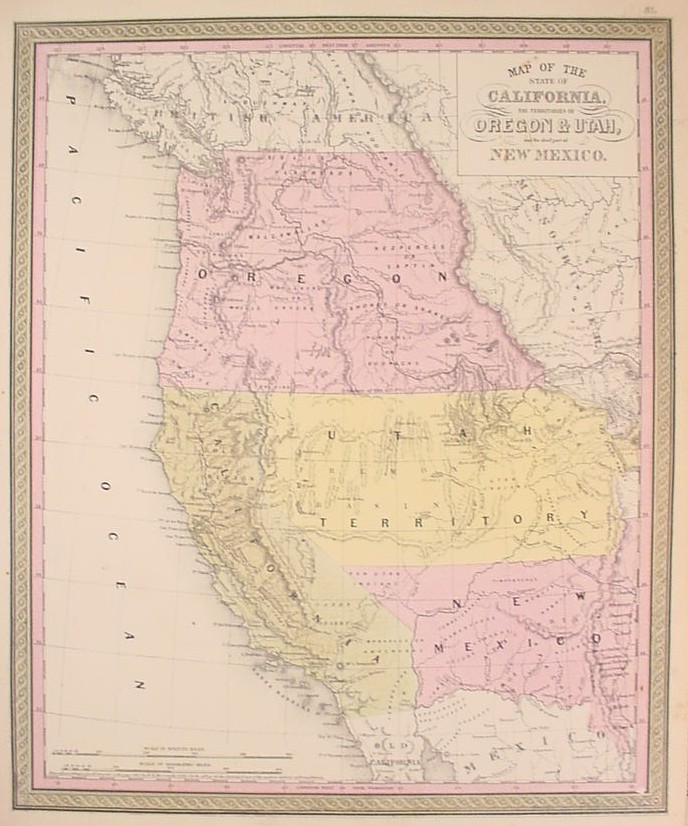
A mid-century map of the western part of the United States, one of the first maps to show the state of California and the territories of Utah and New Mexico. The map is an updated version of a map that appeared in S. Augustus Mitchell's Universal Atlas of 1849. The southern part of the region shown in that map, "Upper California," had just been won from Mexico in 1848, and Mitchell's map was important for presenting the vast new U.S. territories to the American public. In 1850, the rights to Mitchell's atlas were sold to the firm of Thomas, Cowperthwait & Co., which reissued the atlas with some updating. That year the newly acquired lands were divided by Congress into the state of California and two territories, Utah and New Mexico; Thomas, Cowperthwait & Co. revised the Mitchell map accordingly.
Besides the new political information that appeared on this map, what had appeared on the 1849 map as the "Great Interior Basin" is now somewhat filled in based on Fremont's map, renamed "Fremont Basin." Other topographical features included considerable orography, rivers, and lakes. The Great Salt Lake is shown, next to which is "Salt Lake City. Mormon Set.," which had just been settled in 1847. Early settlements and a coastal road are illustrated in California, and the old Spanish trail between Santa Fe and Los Angeles is also indicated. Of further interest is the prominent depiction of the Oregon Trail, shown snaking from present-day Colorado to the Columbia River. The entire region north of Utah and California appears as the Oregon Territory, which it remained until the Washington Territory was created in 1853. Thomas, Cowperthwait & Co. continued to revise this map, for in 1851 they came out with a further up-dated map retitled "A New Map of the State of California," and with more information provided on the counties of the territories and state. This is a fascinating and historical important map, one of the first to show the new political situation in the west after the Compromise of 1850. $875
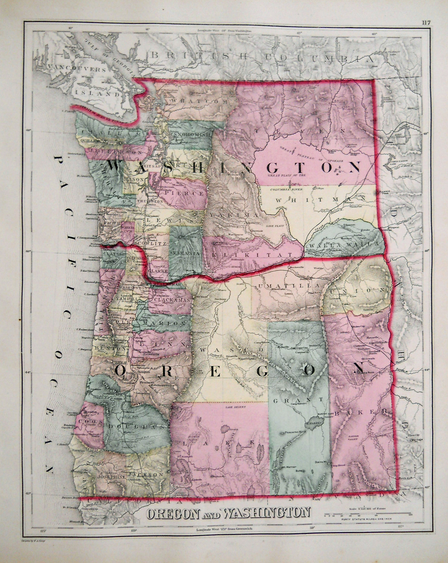
"Oregon." Washington: General Land Office, 1866. 16 1/2 x 22. Lithograph by Major & Knapp. Original outline color. Small break and missing surface at one fold corner. Otherwise, very good condition. Wheat: 1154.
The U.S. General Land Office (GLO) was established in 1812 with responsibility to survey and control the dispersal of public lands. All public land was required to be surveyed prior to settlement, and the first director of the GLO, Thomas Hutchins, set up a systematic process of rectangular survey for the public lands and launched the great national project to survey and map the public domain in the entire country, a procedure which got under way in the famous "seven ranges" of southeast Ohio. Each surveyor was to record not only geography, but also features of the landscape with economic import, such as roads, Indian trails, existing settlements, Indian lands, mineral deposits, and of particular interest, railroads and their rights of way. Of note is that unlike most surveys of the time, the surveyors were instructed not to apply new names to the landscape, but to use "the received names of all rivers, creeks, lakes, swamps, prairies, hills, mountains and other natural objects."
By mid-century the GLO had completed most of the surveys for the lands between the Appalachians and the Mississippi, and so focused most of its attention to the American west for the rest of the century. The GLO published mostly state maps, which were issued in annual reports, bound into state atlases, and in a few atlases that combined all the current maps in progress. These maps produced by the GLO are the most accurate and detailed maps of the U.S., based on rigorous and comprehensive surveys not hindered by commercial concerns. These maps proved very useful to private American mapmakers, and they were often the basis for state and county maps in the second part of the nineteenth century. This map shows the state of Oregon seven years after statehood. The extensive settlement along the Pacific coast is nicely shown and the Cascades depicted with hachuring. The Oregon Central Military Road is shown and gold mines indicated in the northwest. $450
"Oregon and Washington." Philadelphia: O.W. Gray, 1875. 14 3/4 x 12. Lithograph. Original hand color. Very good condition.
A nicely detailed map of the state of Oregon and territory of Washington by the Gray map publishing firm out of Philadelphia. They are shown with their present borders, which were established about a decade before this map. The map shows the considerable development in the region just a year before the nation's centennial. Of particular interest are the railroads, including the California & Oregon and the Northern Pacific as far north as Olympia. $125
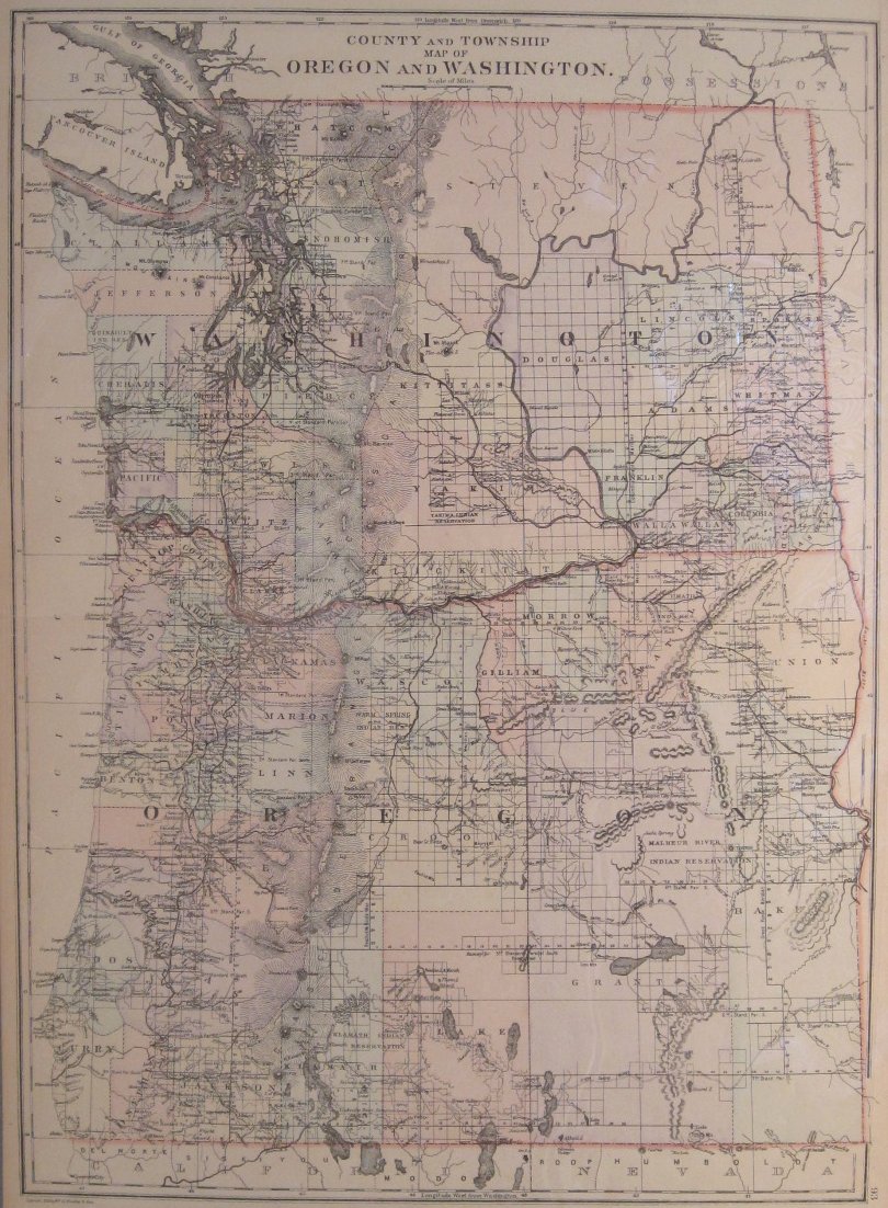
W.M. Bradley. "County and Township Map of Oregon and Washington." W.M. Bradley & Bros., 1886. 19 3/4 x 14 1/2. Original hand outline color. Very good condition.
An updated version of Mitchell's County and Township Map of Oregon and Washington published six years later, and showing the expanded development of the platting system of surveying across the west. Informationally little else has been added to this edition. $75
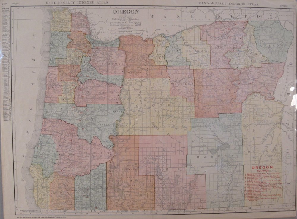
"Oregon." From Rand McNally & Co.'s Indexed Atlas of the World. Chicago: Rand McNally & Co., 1906. 18 1/2 x 26. Very good condition.
Large, colorful atlas map of Oregon detailing roads, railroad lines and topography, and includes an index of major railroads operating within the state. Index to Counties, Creeks, Lakes, Mountains, Rivers, and Towns on reverse. $65
Other map pages: [ Locations | Map themes & related | Cartographers ]


![]()
For further information, please contact:

![]()
106 E. Lancaster Avenue, Lower Level
Wayne, PA 19087 USA
610.808.6165
PhilaPrint@PhilaPrintShop.com ![]()
©The Philadelphia Print Shop Last updated August 10, 2021