|
|
|
|
|
|
|

![]()
The Port Folio was a new type of American magazine, "Devoted to Useful Science, the Liberal Arts, Legitimate Criticism, and Polite Literature." It was a product of the new century, appearing first in January 1801. It began as a weekly issue until 1809, when it became monthly until its demise at the end of 1827. As with the many magazines that followed it, The Port Folio included numerous illustrations, views, and portraits. These include maps, and they are some of the earliest views of American and Canadian sites.
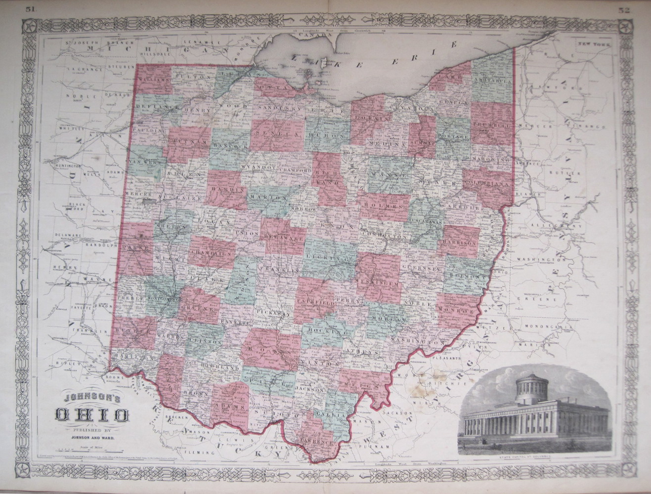
A small map of the vicinity of Zanesville, Ohio, by one of the seminal figures in the history of American cartography. John Melish was the first American publisher to issue exclusively cartographic and geographic items. Born in Scotland and involved in the textile industry, Melish visited the United States several times beginning in 1806, finally deciding to settle there in 1811. Melish had made many notes on his travels about the country and in 1812 he published Travels in the United States of America, which included his first maps and which started him on his cartographic career. Melish came to dominate the industry in this country, and had a huge impact on all subsequent American mapping. This map appeared in his Travels, but it was also sold separately, as stated in an advertisement in Melish's 1819 Traveller's Directory, "Octavo Maps of Philadelphia, New York, Baltimore, Boston, Pittsburg, Zanesville, Falls of Niagara, Falls of Ohio, East End of Lake Ontario and Montreal-12 1/2 cents, each." $110
Fielding Lucas. "Ohio." Philadelphia: H.C. Carey & I. Lea, 1822. 12 x 9 1/2 (map); 16 1/2 x 20 1/2 (full sheet). Engraving by Boyd. Full hand color. With some browning along fold as to be expected. Else, very good condition. $550
Fielding Lucas. "Ohio." From Carey & Lea's American Atlas. Philadelphia: H.C. Carey & I. Lea, 1827. 12 x 9 1/2 (map); 16 1/2 x 20 1/2 (full sheet). Engraving by Boyd. Full hand color. Very good condition.
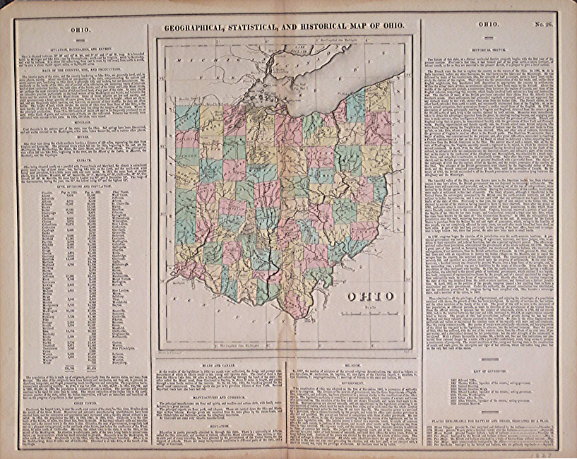
In 1822, Henry Charles Carey and Isaac Lea published their A Complete Historical, Chronological, and Geographical American Atlas. This volume was based on Emmanuel Las Cases' Atlas Historique of 1803, with updated maps and text modified by Carey, a political economist. He considered himself an American foil to John Stuart Mill and the London economists who were proclaimers of "the gloomy science" influenced by Ricardo and Malthus. Instead of preaching overpopulation and degeneration of the human species, Carey illustrated the nations of the western hemisphere through maps that showed an expanding region with ample promise of developing into lands of great new opportunity and growth. The sheets from this atlas, which cover North America, Central America, South America and the West Indies, are comprised of an engraved map surrounded by text documenting the history, climate, population and so forth of the area depicted. The atlas is particularly known for its excellent early maps of the states and territories of the United States. This map of Ohio shows the state at a relatively early stage in its history. The extensive development of the state by 1827, with many counties, settlements and roads, is graphically pictured along with the considerable growth caused by the opening of the Erie Canal in 1825. The text gives the history, climate, and other information on the state, including a listing of the governors so far. A terrific visual and textural picture of Ohio. $550
"Ohio." Philadelphia: A. Finley, 1827. From A New General Atlas. 11 1/4 x 8 1/2. Engraving by Young & Delleker. Original hand coloring. Full margins. Fine condition. $250

S.A. Mitchell. "Map of the States of Ohio, Indiana, and Illinois with the settled parts of Michigan." Includes southern part of Wisconsin plus four added insets. Philadelphia, 1836. Copyright 1834. Engraving by J. H. Young (hand colored). Full decorated margins. 17 1/2 x 22 (sheet). Folding map on bank note paper. One expertly repaired hole at the intersection of two folds, near Peoria, IL.
A dramatic map illustrating the growth of the American Midwest as development was burgeoning. Detailed insets include vicinities of Detroit, Cincinnati, Louisville ["Falls of Ohio"], and "Lead Region East of the Mississippi River." The map accounts for roads, railroads and steamboat routes. Here is a product of the best mapmakers of their times in America. A very beautiful and important cartographic achievement as the United States developed in the 1830s at an astonishing rate. $850

Thomas G. Bradford. "Indiana & Ohio." From Atlas Designed to Illustrate The Abridgement of Universal Geography. Philadelphia: Desilver, Thomas & Co., 1835. Quarto. 7 7/8 x 10. Engraving by G.W. Boynton & Co. Original hand color. A few spots, else, very good condition.
A nice map from Boston publisher and cartographer, Thomas G. Bradford. Issued in 1835, Bradford's Atlas contained maps of the different United States and other parts of the world, based on the most up-to-date information available at the time. Towns, rivers, lakes, and some orography are depicted. Counties are named and indicated with original outline color. Because Bradford continued to update his maps as he issued them in different volumes, this political information is very interesting for historic purposes. This map is interesting as it shows the states at an early stage in their development. Of note is the indication of Indian tribes and of railroads and canals in both states. This is a good representation of American cartography in the fourth decade of the nineteenth century and an interesting document of regional history. $125
S. Augustus Mitchell. "A New Map of Ohio with its Canals, Roads & Distances." From A New Universal Atlas. Philadelphia: S. Augustus Mitchell, 1848. 14 x 11 1/2. Lithograph transfer from engraved plate. Original hand-coloring. Full margins. Good condition, but with spots.
A striking map of Ohio by S. Augustus Mitchell, issued in 1848. For much of the middle part of the nineteenth century, the Mitchell firm dominated American cartography in output and influence. S. Augustus Mitchell Jr.'s maps of the 1860s are probably the best known issues of this firm, but his father's earlier efforts are excellent maps derived from H.S. Tanner's atlas of the 1830s. This early map of Ohio is a good example of this work. Topographical information, including towns, rivers, etc. is clearly shown, and the counties are shaded with contrasting pastel shades. Of interest is the depiction of the burgeoning transportation network, with the canals, roads, and railroads particularly noted. At the top is a list of the steam boat routes in the state, while at the bottom is a profile of the Ohio Canal, running from Portsmouth to Cleveland. It is obvious from the quality and attractive appearance of this map why Mitchell's firm became so important. A nice early American cartographic document of the state. $185
Henry S. Tanner. "A New Map of Ohio with its Canals Roads & Distances." From Universal Atlas. Philadelphia: S. Augustus Mitchell, 1849. 14 x 11 1/2. Lithograph transfer from engraved plate. Original hand-coloring. Full margins. Very good condition.
An updated version of Tanner's map of Ohio, issued by S. Augustus Mitchell in 1849. For much of the middle part of the nineteenth century, the Mitchell firm dominated American cartography in output and influence. S. Augustus Mitchell reissued Tanner's atlas and established a thriving cartographic firm that was later taken over by his son S. Augustus Mitchell Jr. The quality of this map, with its richly presented detail, gives evidence of why the firm was such a success. $225
"Map of the State of Ohio." Philadelphia: Thomas, Cowperthwait & Co., 1850. 15 3/4 x 13. Lithographic transfer from engraved plate. Full original hand color. Very good condition. $250
"Colton's Railroad & Township Map of the State of Ohio." New York: J.H. Colton & Co., 1852. Separately issued map, printed on bank note paper and folded as issued, but missing original cover. 24 x 28. Lithograph. Original hand colored railroad lines. Very good condition.
A very detailed, separately issued folding map of Ohio from the J.H. Colton firm of New York. Throughout the nineteenth century, separately issued maps played an important role in American life. Used by immigrants, travelers, and businessmen, these maps were crucial to the public in that increasingly mobile age. The Colton firm specialized in travelers' maps such as this, which would have been sold in New York and through dealers around the country. Most such maps would have be destroyed or severely damaged through use, but this example has survived in fine condition. This map was issued at a time when many immigrants and easterners were moving to the mid-west, so it would have been a popular map. The map shows excellent detail of towns, political divisions, rivers, lakes and the road network. One of the primary foci of this map is its depiction of the railroads criss-crossing the state. Also included is an engraved image of the State Capitol in Columbus in the lower right. $675
"Ohio." New York: J.H. Colton & Co., 1856. 13 x 15 3/4. Lithograph. Original hand color. Very good condition.
In the mid-nineteenth century, the center of map publishing in America moved from Philadelphia to New York. The J.H. Colton publishing firm played a large role in this shift. This map of Ohio, with its fine detail, is a strong example of their successful work. The map presents the counties in contrasting pastel shades, and includes depictions of towns, rivers, marshes, and some topography. Of particular interest are the indications of the burgeoning transportation network in the state, with roads and railroads clearly shown. $135
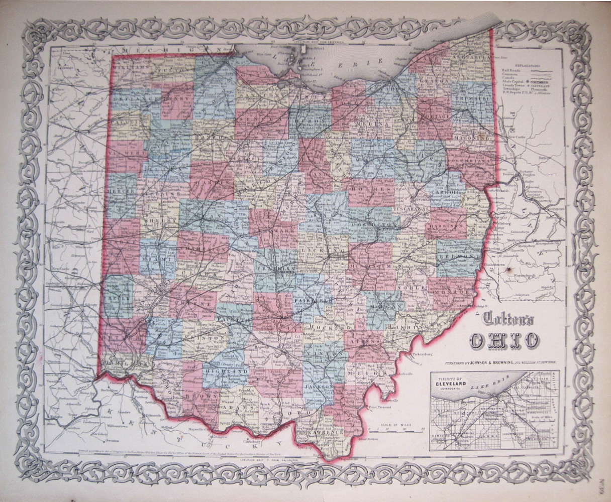
A.J. Johnson. "Johnson's Ohio." New York: Johnson & Ward, 1864. 16 3/4 x 22 3/4. Lithograph. Full original hand-color. Full margins. Very good condition.
An attractive map of Ohio from A. J. Johnson's mid-nineteenth century atlas of the world. Johnson, who published out of New York City, was one of the leading cartographic publishers in the second half of the century, producing popular atlases, geographies and so on. This map, showing fine detail of the state, is an excellent example of Johnson's, and thus early American, cartography. Detail includes roads, towns, cities, railroads, rivers, lakes, and canals. Townships are marked and counties are indicated with contrasting color. In the lower right corner is an inset engraving of the state Capitol at Columbus. $150
"Ohio." Publisher unknown. 1884. 11 x 8 3/4. Cerograph. $40
"County Map of the State of Ohio." Philadelphia: W.M. Bradley & Bro., 1887. 13 3/4 x 11 3/4. Lithograph. Original hand color. Very good condition. $75
"Ohio." Philadelphia: W.M. Bradley & Bro., 1889. 22 1/4 x 16. Lithograph. Original hand color. Repaired tear. Else, very good condition. $125
"Ohio." Chicago: Rand McNally, 1898. 9 1/4 x 11 1/2. Cerograph. With map of Cincinatti on verso. $50
"Ohio." Chicago: Rand McNally, 1899. 19 x 25 3/4. Double page. Cerograph. With inset map of Hamilton County. $125
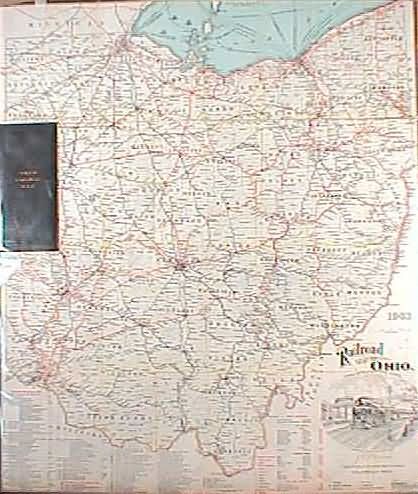
J.C. Morris. "Railroad Map of Ohio." Columbus, OH: State of Ohio, 1903. Credit reads, "Prepared under the direction of J.C. Morris." Printed by The Columbus Lithograph Co. 32 1/4 x 28. Backed on linen and folded into 32 sections as issued. Original art buckram covers. Very good condition.
An excellent map of the state showing lines of 36 major railroads and their subsidiaries as well as 50 electric or traction railroads. Topographical information is restricted to rivers and streams, but each county and township is depicted with major population centers. Canals, coal lands, and tunnels are marked by symbols, and the routes of steamships in Lake Erie are shown. The lovely symbolic title cartouche illustrates forms of transportation which include an early automobile and an engine named "Morris" to celebrate the commissioner of railroads and telegraphs who directed the production of this fine map. $275
"Ohio." New York: Dodd, Mead, 1903. 10 1/2 x 8 1/2. $35
"Ohio." Chicago: Geographical Publishing Co., 1930. 21 x 14 1/2. $45
Other map pages: [ Locations | Map themes & related | Cartographers ]


![]()
For further information, please contact:

![]()
106 E. Lancaster Avenue, Lower Level
Wayne, PA 19087 USA
610.808.6165
PhilaPrint@PhilaPrintShop.com ![]()
©The Philadelphia Print Shop Last updated July 15, 2021
![[Fort Stephenson (or) Lower Sandusky Fort.]](images/portfolio315.jpg)