|
|
|
|
|
|
|

[ Maps of Europe ]
![]()

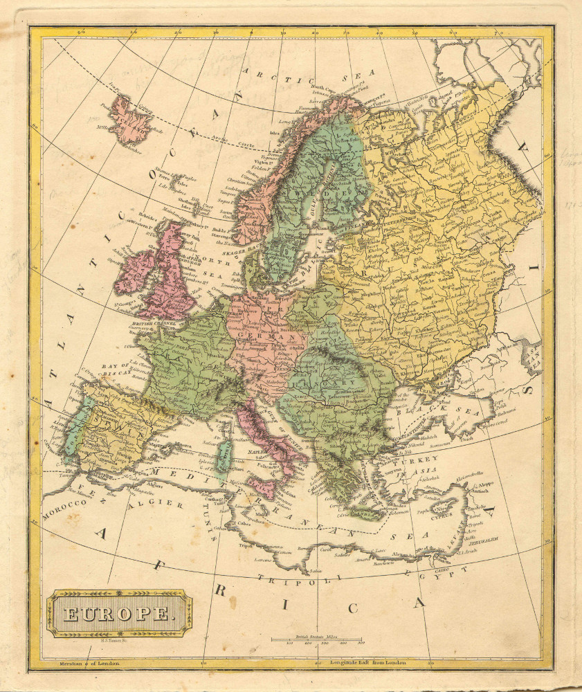
One of a series of beautiful maps of all parts of the world. Georg Matthäus Seutter was one of the most important of the German cartographers, being appointed as the Geographer to the Imperial Court. His son, Albrecht Carl, joined Matthäus and eventually inherited the business. The maps from this atlas were drawn by the two Seutters and were engraved by Tobias C. Lotter, who later took over the business from Albrecht. These maps, typically of German output, are highly detailed and engraved with a bold hand. Equally strong is the original hand color in the body of the map. The cartouches were left uncolored in order to emphasize the elaborately detailed illustrations for which German maps are especially prized. These are some of the most decorative and interesting maps of the mid-eighteenth century. $425
Emanuel Bowen. "A New & Accurate Map of Europe." From John Harris' Complete Collection of Voyages and Travels. London, 1748. 14 1/2 x 18. Engraving. Small spots in lower right and left corners, not affecting image. Else, very good condition.
Emanuel Bowen was a map engraver, printer and publisher in London in the mid-eighteenth century. He achieved considerable success in this field, being appointed as engraver to both Louis XV of France and George II of Britain, and later as Geographer to the latter. He produced some of the most interesting maps of his time. Despite his royal appointments and apparent success, Bowen died in poverty in 1767. Through all the vicissitudes of his life, however, Emanuel Bowen's maps continued at a very high level of quality, as exemplified by this nicely detailed map of Europe, "Drawn from the best Authorities, assisted by the most approved Modern Charts & Maps, and adjusted by Astronomical Observations." Interior detail is copious and accurate. Bowen includes charming decoration on the title cartouche, an allegorical depiction of the rivers of Europe and a small sailing ship as homage to the British tradition of trade. $275

A nicely rendered map of Canada from William Guthrie's famous geography. William Guthrie (1708-1770) was a historian who came out in 1769 with a General View of Geography. This work proved very popular and he soon revised the work, adding maps. "Guthrie's Geography" went through many different editions, well past his death, with editions to as late as 1842. Later editions were regularly updated and expanded, with new discoveries and maps added. $200
Fielding Lucas Jr. "Europe." From A New and Elegant General Atlas Containing Maps of each of the United States. Baltimore: F. Lucas, Jr., 1816. Folio. Engravings. Full original hand color. Light manuscript and blemishes in margins. Scattered small spots. Else, fine condition.
A fine map showing all of the Mediterranean by Baltimore cartographer, Fielding Lucas Jr. (1781- 1854). Lucas appears to have become involved in the publishing and book trade while a resident of Philadelphia from 1798 to 1804, when he moved to Baltimore. In 1807 Lucas joined Conrad, Lucas & Co., and then in 1810 he set up his own business at 138 Market Street. There Lucas first got involved in cartographic publishing with his New and Elegant General Atlas of 1816. In the second decade of the nineteenth century, through his Philadelphia contacts, Lucas was one of the major contributors to Carey & Lea's atlas of 1823. Concurrently with this involvement, Lucas brought out his own General Atlas, containing 104 maps of all parts of the world. Lucas, during his 50 years of residence in Baltimore, established himself as a prominent citizen of that city, serving as President of the Baltimore and Ohio Railroad, President of the Board of School Commissioners, and as President of the Second Branch of the City Council. But it is for his important role in early American cartography that Lucas is best remembered. $150

John Cary. "Europe." From Cary's New Universal Atlas. London: J. Cary, 1816. 9 x 11 1/8. Engraving. Original hand color. Scattered light foxing, mostly in margins. Else, very good condition.
A detailed map of Europe by John Cary (ca. 1754-1835), the founder of the famous English cartographic firm. From about mid-way through the eighteenth century, British cartographers were the best in the world, and the maps produced by Cary are good examples of the quality they achieved. Cary was very concerned with the changing political situation in the world, so this map shows Europe at that date. Rivers, towns, political divisions, and topography are presented with crisp engravings, the hatchuring along the coastline giving the map a three-dimensional appearance. The subtle hand coloring adds a decorative touch to this fine early nineteenth century historic document. $150
John Thomson. "Chart of the Mediterranean Sea." From A New General Atlas. Edinburgh: J. Thomson, 1817. 19 1/8 x 19 3/4. Engraving by Neele. Full original hand color. Fine condition.
A striking map of the Mediterranean with insets of seven locations along the coast, clockwise from top left: Marseilles, Genoa, Gibraltar, Gulf of Smyrna, Algiers, Algeziras and Leghorn Road. Countries are carefully named and indicated with contrasting outline colors. The delicate hand coloring highlights the information given, making the map both easier to read and pleasing to look at. Altogether, a fine example of early 19th-century British cartography. $250
From C. V. Lavoisne's A Complete Genealogical, Historical & Chronological Atlas. Philadelphia: M. Carey & Son, 1820+. Engravings. Original hand color. Very good condition.
Maps issued to illustrate Lavoisne's Historical Atlas. The maps in this atlas were issued on sheets containing text around the maps giving the situation and history of the areas depicted. These maps of the Mediterranean region show the sea, along with the surrouding nations.

"Migrations, Settlements &c. of Barbarous Tribes illustrating the account which is given of them in Willard's Ancient Geography." Hartford: Oliver D. Cooke & Co., 1827. 8 3/8 x 11 3/8. Lithograph. Original hand color. Narrow margin at right; toning at edges of margin. Else, very good condition. $25

David H. Burr. "Europe." From A New Universal Atlas (1835). New York: David H. Burr, 1834. 12 1/2 x 10 1/4. Engraving. Full original color. Chips and discoloring in upper corners of margin. Else, very good condition.
An excellent map of Europe by David H. Burr, one of the most important American cartographers of the first part of the nineteenth century. Having studied under Simeon DeWitt, Burr produced the second state atlas issued in the United States, of New York in 1829. He was then appointed to be geographer for the U.S. Post Office and later geographer to the House of Representatives. A careful geographer, Burr's maps are scarce and quite desirable. $85

John Dower. "Europe." From A New General Atlas of the World. London: Henry Teesdale & Co., 1834. 13 1/4 x 16 1/8. Folio. Engraving by J. Dower. Original hand color. Very good condition.
A map of Europe by British cartographer John Dower. Though other countries, including the United States, had by then developed cartographic industries of considerable quality, British map publishers were still the best in the world. This map is typical of their output, with clear and precise engraving depicting copious up-to-date information. Towns, rivers, political boundaries and topography are shown throughout. The hand coloring, beautifully applied, makes this map as handsome as it is interesting. $175

Thomas G. Bradford. From A Comprehensive Atlas. Geographical, Historical & Commercial. Boston: 1835-42. Ca. 7 3/4 x 10. Engravings. Original outline color. Full margins. Excellent condition.
Small maps published in Boston circa 1840 showing the Old World through the lens of the first half of the nineteenth century. Information shown includes rivers, towns and roads, both existing and proposed.

Henry Tanner. "Europe." From Universal Atlas. Philadelphia: Carey & Hart, 1843. 11 1/4 x 14 1/4. Engraving by E.B. Dawson. Original hand color. Very good condition.
A map of Europe by the great American cartographer, Henry Schenck Tanner. Beginning at the end of the second decade of the nineteenth century, Tanner, produced his important American Atlas, the finest American produced atlas to the time. The American Atlas was a huge success and this inspired Tanner, in 1834, to produce his Universal Atlas, of more manageable size. All details are clearly presented and these include towns, rivers mountains, political boundaries and some transportation information. In 1844 Carey & Hart issued an updated edition of the Tanner atlas. These maps were later purchased by S. Augustus Mitchell, and then Thomas, Cowperthwait & Co., but maps from the early Carey & Hart edition are quite rare. This is a typical example of the maps from that atlas, with excellent and current information. $110

Henry S. Tanner. "Europe." Philadelphia: S.A. Mitchell Sr., 1846. 12 x 15 1/8. Lithographic transfer from copper engraving. Original hand color. Very good condition.
A crisp, detailed map of Europe by the great American cartographer, Henry Schenck Tanner and published by Samuel Augustus Mitchell Sr., one the leading cartographic publishers of the period. Beginning in 1819, Tanner published his American Atlas, which was a huge success. This inspired Tanner to produce his Universal Atlas, of more manageable size, which contained fine maps of each state and a number of cities. These maps were purchased by S. Augustus Mitchell and reissued in his editions of Tanner's atlas. Mitchell was born in Connecticut where he engaged in teaching. Upon the discovery that geography texts were inadequate, he wrote his own and in 1829-30 moved to Philadelphia, then the leading publishing center in the United States. He acquired the stock and plates of Anthony Finley's publishing company and improved on those copper plate maps. In 1846, with the issuing of his New Universal Atlas, Mitchell began using the new technique of stone lithography. $85

A.K. Johnston, F.R.S.E. "The Mountain Systems of Europe Costructed on the basis of Contour Lines." Edinburgh: W. & A.K. Johnston, 1854. 18 1/2 x 25 1/2. Color lithograph. Wear along folds; paper toned; scattered light stains. Else, good condition.
An interesting map of the continent. Topographical detail is extensive and clear. $175

S. Augustus Mitchell, Jr. "Map of Europe showing its Gt. Political Divisions." Philadelphia: S. Augustus Mitchell, Jr. 1860. 10 5/8 x 13 1/4. Lithograph. Original hand coloring. Full margins. Decorative border. Very good condition.
For most of the middle part of the nineteenth century, the firm founded by S. Augustus Mitchell dominated American cartography in output and influence. This fine map is from one of his son's atlases. The map depicts and names streets, rail lines, and major buildings. Each ward is colored in a contrasting pastel shade. This map was republished in several editions and it provided more readers with information about Philadelphia than any other map of the period. A fine decorative border surrounds the map, and the whole effect makes for an attractive mid-nineteenth century map. $45
"The Mediterranean and Black Seas -- Physical." London: The London Geographical Institute, 1909-27. 12 3/4 x 18. Color offset by George Philip & Son, Ltd. Excellent condition.
A study of the two seas with elevations and sea depths depicted in color, with insets: "The Mediterranean and Black Seas showing the Visibility of the Land," and "A Section of the Mediterranean Sea." $45
Other map pages: [ Locations | Map themes & related | Cartographers ]


![]()
For further information, please contact:

![]()
106 E. Lancaster Avenue, Lower Level
Wayne, PA 19087 USA
610.808.6165
PhilaPrint@PhilaPrintShop.com ![]()
©The Philadelphia Print Shop Last updated July 15, 2021