|
|
|
|
|
|
|

![]()
Woodcut map by Sebastian Munster (1489-1552) from the sixteenth century. The wood block was made in Basel, Switzerland for an earlier edition of the Cosmographia, and this printing was done for a subsequent edition in Venice. Visually and historically fascinating map.
A small map taken from a later edition of Magini's version of Ptolemy's Geographia, originally engraved by Girolamo Porro and published in Venice in 1596. The strap-work border and fine engraving make this a charming map from four hundred years ago. $185
Maps from the Mercator-Hondius Atlas. Amsterdam: Jodocus Hondius. Engravings. Full original color. Full margins.
Gerard Mercator (1512-1594) ranks as one of the greatest cartographers in history, not only for the extremely fine maps he produced, but also for the innovations which he introduced into cartographic science. Through his constant accumulation of new geographic and cosmological data, Mercator was able to produce the most accurate and current maps of his day, which unlike most of his contemporaries' maps were mostly original work. Mercator intended to produce a complete description of creation, heaven, the earth and the seas, a project he was only beginning when he died. Such was his influence that the title he chose for this projected work, "Atlas," has now become the generic name for all collections of maps.
Jodocus Hondius (1563-1611), who shared a vision similar to Mercator's, took up Mercator's ambitious project after the latter's death, purchasing Mercator's plates in 1604 and publishing a series of editions of the Mercator-Hondius Atlas, beginning in 1606. This series of constantly updated atlases reflected Hondius' continued pursuit of geographical knowledge and craftsmanship in order to produce a superior work. The maps are especially excellent, with superb, bright original hand-coloring and fine condition.
1609 edition. French text on verso.
Blaeu's monumental Nouvel Atlas came to include maps of every nation in Europe, as well as smaller regions. These maps were made with great care, both in terms of geographic content, but in the quality of the production. This map of Luxembourg is beautifully engraved, printed and colored. $750
![]() Go to page with Blaeu regional maps of the Low Countries.
Go to page with Blaeu regional maps of the Low Countries.
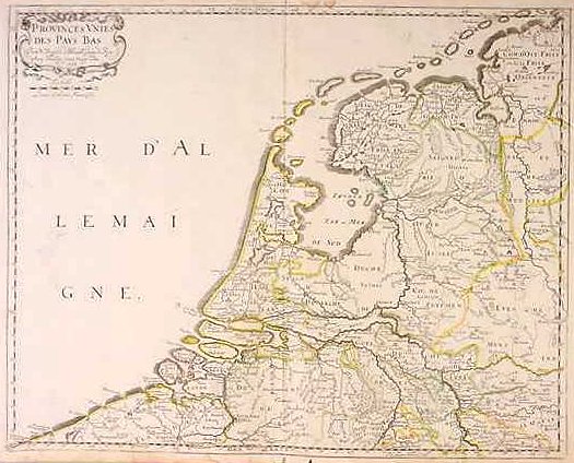
Nicolas Sanson. "Provinces Unies des Pays Bas." Paris: Sanson, 1648. 16 1/8 x 20 1/8. Engraving. Original outline color. Some minor blemishes in margins. Very good condition.
A fine map of Low Countries by 'the father of French cartography,' Nicolas Sanson. Sanson is noted for his use of up-to-date scientific information, and this map one of the best depictions of the Netherlands that was available at the middle of the seventeenth century. This map is of particular interest as it was issued the year that the Republic of the United Provinces (the seven northern provinces of the Low Countries) was recognized as an independent nation in the Treaty of Westphalia. The Dutch, though divided between the Protestants of the north and the Catholics of the south, had been fighting Spanish rule from 1567 when King Philip had sent the Duke of Alba to subdue these Netherlands. The southern provinces (today's Belgium) eventually accepted Spanish dominion, but the northern provinces (today's Netherlands) fought on until they won independence this year this map was issued. Besides its historic interest, this map has a nice decorative air, with a baroque title cartouche in the upper left and original hand coloring. $575
![]() Go to listing of maps by Nicolas Sanson
Go to listing of maps by Nicolas Sanson
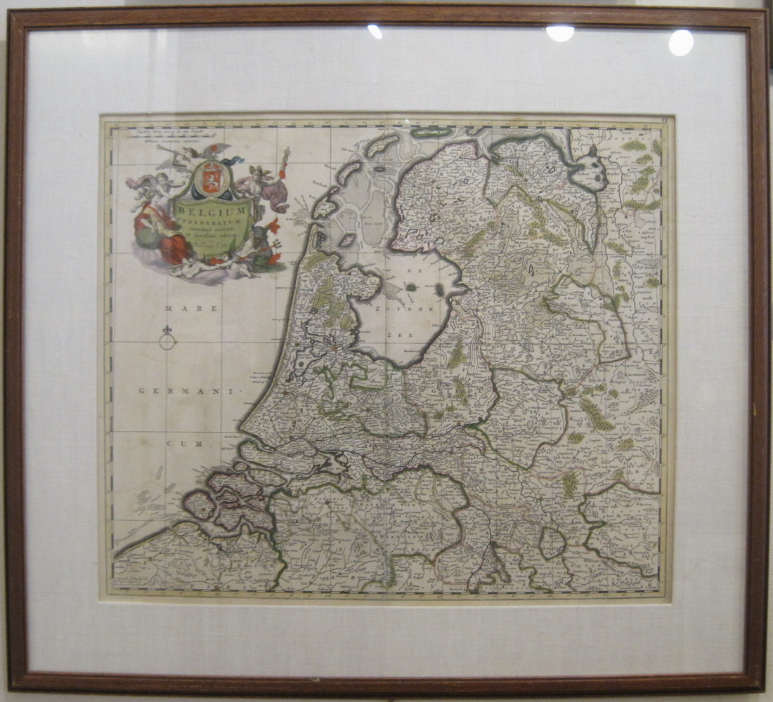
Frederick De Wit. "Belgium Foederatum emendate auctum et noviffime editum." Amsterdam: F. De Wit, ca. 1680. 18 1/2 x 21 1/2. Engraving. Excellent original color. Excellent condition with full margins. Framed.
A lovely seventeenth century map of Belgium by Frederick de Wit. De Wit followed in the footsteps of the earlier Dutch cartographic publishers Jansson and Blaeu, and like them, he issued maps known for their beautiful engraving and hand coloring. Detail is dense and accurate, with the political regions and islands distinguished by the attractive hand colored borders. An elaborate and highly decorative title cartouche is placed in the upper left corner, with classical figures surrounded by objects representing the arts and knowledge of the ancients. $1,200
Other map pages: [ Locations | Map themes & related | Cartographers ]


![]()
For further information, please contact:
![]()
106 E. Lancaster Avenue, Lower Level
Wayne, PA 19087 USA
610.808.6165
PhilaPrint@PhilaPrintShop.com ![]()
©The Philadelphia Print Shop Last updated July 15, 2021
![[Brabantia, Gulick et Cleve.]](images/mercbrb13.jpg)