|
|
|
|
|
|
|

Other map pages:
[ Locations | Map themes & related | Cartographers ]
![]()
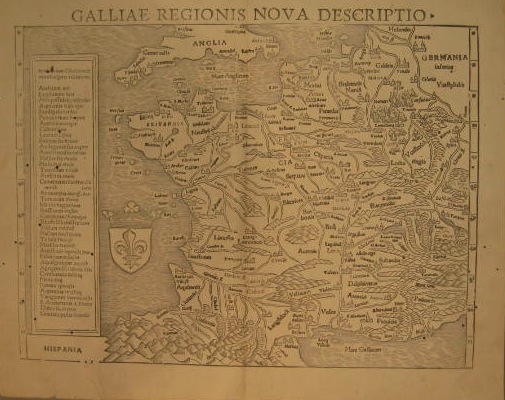
A woodcut map of France by Sebastian Munster (1489-1552) from an edition of his Cosmographia. Munster, a Swiss theologian, mathematician and cosmographer, was one of the greatest geographers in the era before "modern" cartography, and beginning in 1540 he issued numerous maps and views, many in his important Cosmographia. His output was a most influential cause of the spread of geographic knowledge from the middle years of the sixteenth century. His works have aptly been described as Renaissance knowledge through a Medieval medium. This is one of the earliest available map of France and a fine example of one of the premier cartographers of the sixteenth century. $475
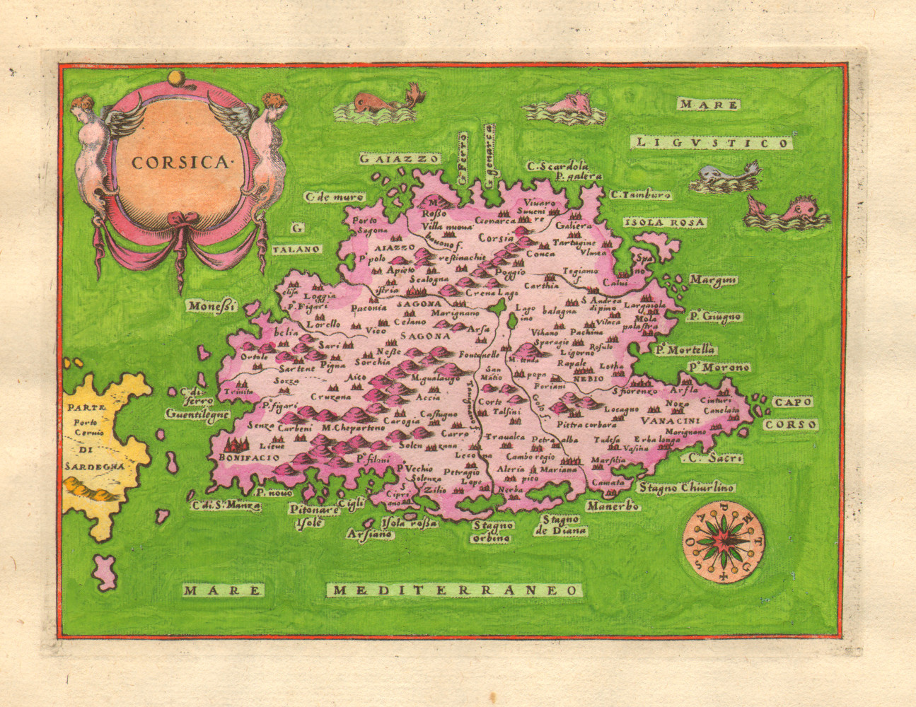
"Corsica." Venice: Porcacchi, 1576-1586. Engraving. 4 x 5 1/2. Hand color. On a small folio sheet 10 3/4 x 7 1/2. The initial woodblock letter "C" is hand colored. Text is Italian. Full margins. Excellent condition.
Tomaso Porcacchi da Castiglione (ca. 1530-1585) is best known for his atlas depicting the islands of the world titled L'Isole. Many editions were published containing seventeen to thirty maps of islands and two of the world. Most showed Mediterranean islands where the Venetian Navy predominated. $225
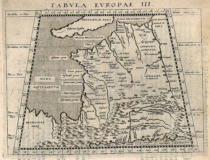
Girolamo Porro after Giovanni Magini. "Tabula Europae III." From Giovanni Magini's Geographiae Universaetum Tum Veteris Tum Novae. Cologne: Peter Keschedt, 1597. 4 7/8 x 6 5/8. Engraving. Full margins. Strong impression. Excellent condition.
Girolamo Porro's Ptolemaic rendition of France, issued in Giovanni Magini's translation of Ptolemy's Geography. The bold calligraphy is particularly decorative, especially within the stark trapezoidal shape that marks a Ptolemaic map. A nice early map of France from the end of the sixteenth century. $90
Gerard Mercator. Mercator-Hondius Atlas. Amsterdam: Jodocus Hondius, 1613. 13 3/8 x 16 5/8. Engraving. Full original color. Full margins. Fine condition. Latin text on verso.
Gerard Mercator (1512-1594) ranks as one of the greatest cartographers in history, for the extremely fine maps he produced and for the innovations which he introduced into cartographic science. Mercator stated that small sections of the earth were not significantly distorted toward the poles if longitude lines were represented as parallel by squares or rectangles. The development of the "Mercator projection," which became the established convention, was particularly important for the improvements it allowed in navigational methods.
Through his constant accumulation of new geographic and cosmological data, Mercator produced the most accurate and current maps of his day. Mercator intended to produce a complete description of creation: heaven, the earth and the seas, a project he was only beginning when he died. Such was his influence that the title he chose for this projected work, "Atlas," has now become the generic name for all collections of maps.
Jodocus Hondius (1563-1611) shared Mercator's vision; he took up Mercator's ambitious project after the latter's death, purchasing Mercator's plates in 1604 and beginning in 1606, publishing a series of editions of the Mercator-Hondius Atlas. This series of constantly updated atlases reflected Hondius' continued pursuit of geographical knowledge and craftsmanship in order to produce a superior work. The maps from this particular Mercator-Hondius Atlas, issued in 1613, are especially excellent, with superb, bright original hand-coloring.
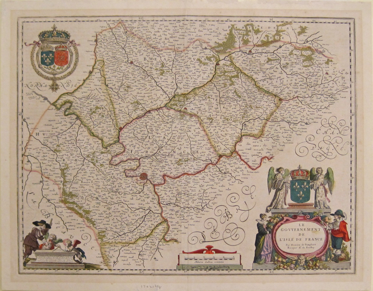
Willem Blaeu. "Le Gouvernement de L'Isle de France." Amsterdam: W. Blaeu, ca. 1640. 15 3/4 x 20 1/4 (neatlines). Full margins. Engraving. Original hand coloring. Latin text on verso. Excellent condition.
An elegant map of the region surrounding Paris by Dutch cartographer Willem Blaeu. Blaeu (1571-1638) was the progenitor of the famous Blaeu cartographic firm of Amsterdam. He studied astronomy and sciences with Tycho Brahe, and in 1599 established a globe and instrument making business which soon expanded to include cartographic and geographic publishing. This firm was to go on to become the largest and most important cartographic publishing firms in the world, later run by his sons Cornelis (until his death in 1642) and Joan. The maps issued by the Blaeu firm are known for their fine engraving and design, and have been called "the highest expression of Dutch cartographical art." This is a good example of the quality of the firm's work, with topographical information carefully engraved and named according to the most up-to-date information. The three baroque cartouches are beautiful decorative additions to this fine seventeenth-century document. $800

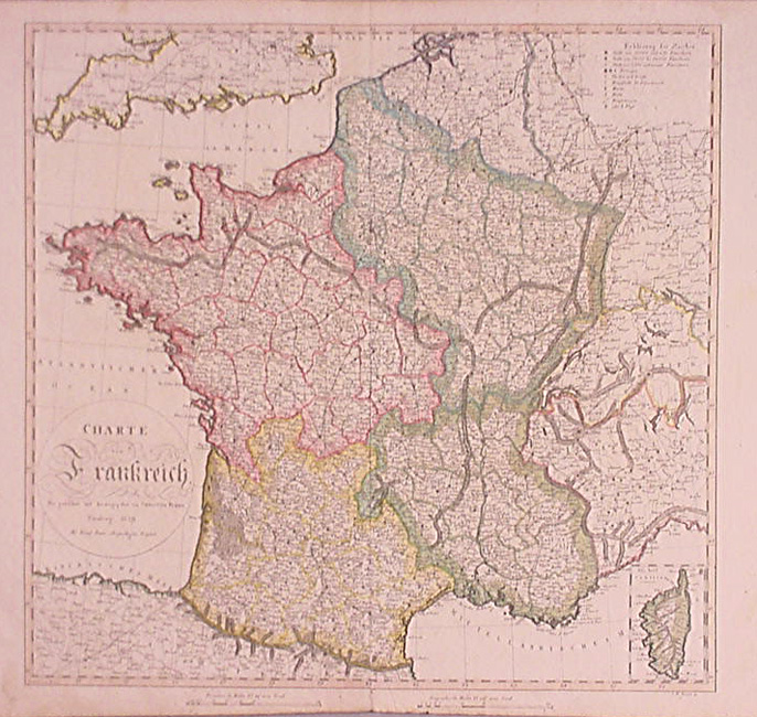
Frederick De Wit. "Accuratissima Galliae Tabula Gallis vulgo dicta le Royaume de France . . ." Amsterdam: F. De Wit, ca. 1680. 19 1/8 x 22 5/8. Engraving. Original hand color. Repaired separation at center fold. Overall, very good condition.
A lovely seventeenth century map of France by Frederick de Wit. De Wit followed in the footsteps of the earlier Dutch cartographic publishers Jansson and Blaeu, and like them, he issued maps known for their beautiful engraving and hand coloring. Detail is dense and accurate, but it is for the aesthetic features that this map most shines. The original hand color is carefully applied and enhances the elaborate title cartouche; a scale of miles completes the decorative features. $725

John Senex. "France Corrected from ye Observations made by the Royal Academy of Sciences at Paris By John Senex. Inscrib'd to the Right Hono'ble Charles Boyle &c. 1720." London: J. Senex, 1720. 25 x 36. Line engraving. Original hand-color. Good impression. Old repair at bottom center near fold.
A large and attractive map of France, issued in 1720 by John Senex, a well-known English cartographer. The nation is shown with considerable detail of rivers, lakes, mountains, as well as towns and cities. The provinces are indicated with contrasting original hand-coloring. This interesting topographical information is presented in a strong engraved style typical of early eighteenth century English maps, and this is nicely set off by the elaborate title cartouche in the upper right corner. This finely etched vignette shows an idyllic scene of French agriculture and symbols. Overall, a wonderful historic French artifact of nearly 300 years ago. $375
Johann Baptist Homann. "Comitatus Burgundiæ tam in Primarias Eius Præfecturas quam in Minores earundem Balliviat . . ." From Atlas Liber die Gantze Welt. Nuremberg: Homann Heirs, 1730+. 22 1/2 x 18 7/8. Engraving. Full original hand color. Narrow margins, with considerable wear. Image and color good. Overall, very good condition.
While the French and then the English generally dominated the cartographic world in the eighteenth century, the Homann firm from Nuremberg, Germany was producing many influential maps and atlases during this time. The firm was founded about 1702 by Johann Baptist Homann, who was appointed Geographer to the Emperor in 1715. In 1724, upon J.B. Homann's death, the company passed on to his son, Johann Christoph Homann and then to his heirs, who traded under the name of Homann Heirs from 1730 into the nineteenth century. The maps from this atlas are typical of the detailed, bold, and romantic style of the Homann cartographic output. Of the Homann style, particularly important is the use of cartouches with surrounding vignettes signifying important characteristics of the country in question. In general, these are large and attractive maps. This map of Burgundy is typical, with two lovely, bold cartouches, and strong engraving and color. $250
"An Accurate Map of France Drawn from the Sieur Robert, with Improvements." From The New Geographical Dictionary. London: 1759. 7 3/4 x 11 1/8. Engraving by G. Rollos. Very good condition.
A fine, easy to read small map of France published for an English readership. Informative and clear. $50
Jean Janvier. From Atlas Moderne. Paris: Jean Lattré & J. Thomas, 1762. Each ca 12 1/4 x 17 1/2. Engraving by Lattré. Original outline color. Very good condition.
Jean Janvier was a French cartographer who worked in Paris in the latter part of the eighteenth century. Among his output were some fine maps which appeared in Jean Lattré's Atlas Moderne. This atlas contained maps of all parts of the world engraved by Lattré, the "Graveur Ordinaire du Roi." Janvier's maps contained the best information available at the time, done with typical French precision and care. The maps have finely etched title cartouches, showing symbols of French history and arts, in the lower left corners.
Rigobert Bonne. "La France par Generalités." From Bonne's Atlas de toutes les parties connues du Globe Terrestre. Paris, 1780. 8 3/8 x 12 5/8. Engraving. Very good condition.
Rigobert Bonne was the Royal Hydrographer of France, so his primary interest was in marine charts. However, with his Royal connections and access to the cartographic documents in Paris, Bonne was able to compile maps containing some of the most up-to-date information of his time. The detail is clearly presented, and fascinating to study. This is a fine French map from just before the French Revolution. $50
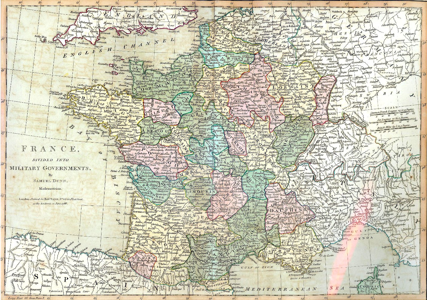
Samuel Dunn. "France divided into its Military Governments." London: Robert Sayer, 1786. 12 x 17. Engraving. Original hand color. Light spots and offsetting, else very good condition.
A handsome British map of France by Samuel Dunn (d. 1794). Besides being a mapmaker, Dunn was a sometimes publisher of maps and atlases, a mathematician, and teacher, who advertised his profession as "S. Dunn Teacher of the Mathematicks London. Boards Young Gentlemen, & Teacheth Penmanship, Merch'ts Acc'ts, Navigation, Fortification, Astronomy &c. Chelsea." Dunn's mathematical inclinations are demonstrated on the precision of this fine map which shows the entire nation across the Channel and the surrounding regions. Topography and political features are precisely engraved. Overall, a fine example of British map-making from the period. $225
John Cary. London: J. Cary, 1799-1806. Each ca. 18 x 20 1/4. Folio. Engraving. Original hand color. Full margins. Very good condition.
Two highly detailed maps of France, published seven years apart, by John Cary (ca. 1754-1835), the founder of the famous English cartographic firm. From about mid-way through the eighteenth century, British cartographers were the best in the world, and the maps produced by Cary are good examples of the quality they achieved. Detail is copious and precisely delineated, including mountains, roads, rivers, towns, lakes and political divisions. Each province or department is colored in a contrasting pastel shade, which makes this a crisp, attractive map. Two fine maps of France from the turn of the nineteenth century.
From Robert Wilkinson's General Atlas of the World, Quarters, Empires, Kingdoms, States etc. with Appropriate Tables. (London, 1812) Ca. 8 3/4 x 11. Engravings. Original hand color.
Typically detailed and neat maps of France from a British atlas of the early nineteenth century. There is a brief history of the provinces in the upper right of the earlier map. With the hand color and precise engraving, the map is decorative as well as historically interesting.
John Cary. From Cary's New Universal Atlas. London: J. Cary, 1816. Ca. 9 1/8 x 11 1/4. Engravings. Original hand color. With scattered, light foxing. Otherwise, very good condition.
Two detailed maps of France by John Cary (ca. 1754-1835), the founder of the famous English cartographic firm. From about mid-way through the eighteenth century, British cartographers were the best in the world, and the maps produced by Cary are good examples of the quality they achieved. Rivers, towns, roads, and other information is clearly presented with very crisp engravings, with an almost three-dimensional topographical appearance. The subtle hand coloring adds a decorative touch to these fine early nineteenth century historic documents.
John Thomson. From A New General Atlas. Edinburgh: J. Thomson, 1817. Each ca. 19 3/8 x 23 3/4. Double folio. Engraving by Kirkwood. Full original hand color. Full margins. Fine condition.
Striking maps of France, from an interesting period of its history. Departments and provinces are carefully named and much attention is given to geographical detail. The delicate hand coloring highlights the information given, making the maps both easier to read and pleasing to look at. Altogether fine examples of early 19th-century British cartography.
Christoph Fembo. "Charte von Frankreich." Nuremberg: Georg Christoph Franz Fembo, 1819. 18 7/8 x 19 5/8. Engraving by I.W. Kneusel. Original hand outline color. Very good condition.
Georg Christoph Franz Fembo (1781-1848) bought Georg Christoph Franz's interest in the Homann Heirs in 1813. He continued to update and publish maps until his death in 1848; thereafter his son, Christoph Melchior Fembo, took over the business. Gone is the elaborate baroque cartouche, in favor of a simplified version, but detail in the body of the map is still excellent and clear. This is a handsome example of early 19th century German mapmaking. $285
From C. V. Lavoisne's A Complete Genealogical, Historical & Chronological Atlas. Philadelphia: M. Carey & Son, 1821. 12 1/2 x 13 5/8. Engravings. Full original hand coloring.
Two brightly colored historical maps of France from Lavoisne's Historical Atlas. Each province or department is named and highlighted with contrasting colors, and its chief city indicated. Also indicated are sites of major battles, sieges in the nation's history. This data is neatly presented, giving each map a clear and colorful appearance.
John Dower. "France." From A New General Atlas of the World. London: Henry Teesdale & Co., 1842. 13 3/8 x 16 3/8. Engraving by J. Dower. Original outline color. Excellent condition.
A handsome map of France by British cartographer John Dower. Though other countries, including the United States, had by then developed cartographic industries of considerable quality, British map publishers were still the best in the world. This map is typical of their output, with clear and precise engraving depicting copious up-to-date information. Towns, rivers, roads, political boundaries and topography are shown from throughout. The hand coloring, beautifully applied, makes this map as handsome as it is interesting. $145
After H.S. Tanner. "France." From S. Augustus Mitchell's A New Universal Atlas. Philadelphia: S. Augustus Mitchell, 1849. 15 5/8 x 12 5/8. Lithographic transfer from engraved plate. Full original hand color. A few scattered spots. Else, very good condition.
In 1846, S. Augustus Mitchell took over publication of H.S. Tanner's Universal Atlas, continuing the run of this important atlas. The maps were based on lithographic transfers of Tanner's engravings, but Mitchell updated each image to show the current political situation. $75
"France." Philadelphia: Thomas, Cowperthwait & Co., 1853. 12 1/8 x 15. Lithographic transfer from engraved plate. Full original color. Very good condition.
A crisp, detailed map of France issued by Thomas, Cowperthwait & Co. This firm took over the publication of S. Augustus Mitchell's important Universal Atlas in 1850, and they continued to produce up-dated maps that were amongst the best issued in the period. The detail of each department is impressive, and a listing at left gives all the provinces. With precise detail and strong hand coloring, this is a fine example of mid-century American cartography. $50
"France." Philadelphia: Charles Desilver, 1856. 15 3/4 x 12 3/4. Lithograph. Original hand color. Very good condition. With decorative border.
Charles Desilver, one of the many publishers working in Philadelphia during the mid-nineteenth century, issued an atlas of maps based on the famous Tanner-Mitchell-Cowperthwait series. Desilver used much the same information as originally drawn in the 1840s, but updated the maps with new roads, towns, and other information. This map is typical of the rather unusual and scarce Desilver atlas. Insets showing "Environs of Paris", and "Corsica". An attractive and fascinating document. $60
"Colton's France." With inset "Corsica." New York: G.W. and C.B. Colton & Co., 1866. 15 7/8 x 13 1/4. Lithograph. Full original hand-coloring. Very good condition.
From the mid-nineteenth century on, the lead in American map publishing swung from Philadelphia to New York. The firm of J.H. Colton and its successors played a large role in this shift, producing accurate and up-to-date maps that had a wide distribution. An excellent map of France by the Colton firm. $50
Other map pages: [ Locations | Map themes & related | Cartographers ]
[ French Provincial Maps | Return to maps of Europe ]


![]()
For further information, please contact:
![]()
106 E. Lancaster Avenue, Lower Level
Wayne, PA 19087 USA
610.808.6165
PhilaPrint@PhilaPrintShop.com ![]()
©The Philadelphia Print Shop Last updated July 15, 2021