 |
||
![]()

![]()

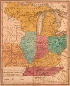
From 1827 to 1829, Philadelphia publisher Anthony Finley produced an American version of Conrad Malte-Brun's famous Universal Geography. Malte-Brun was a Danish geographer who produced a number of influential works which were copied and printed by numerous publishers in different countries. To illustrate the geography, in 1828 Finley added an atlas of 40 maps based on Malte-Brun, which was then reissued the following year by John Grigg. Many of the non-American maps are based on maps by British cartographer Aaron Arrowsmith, but the American maps are Finley's original work, engraved by J.H. Young. The map of the mid-west, "Western States & Territories," is interesting for its depiction of the Michigan Territory and "North West Territory Attached To Michigan." The map of Mexico is of note for its depiction of "Texas or New Estremaduia," for this map was issued near the beginning of the tensions between Austin's colonists and the Mexican government that would lead to the Texas revolution. $2,500
[ Click here for image; southern states ]
Atlas To Accompany Chambers's Encyclopædia. Philadelphia: J.B. Lippincott & Co., 1869. Quarto. Cloth binding with wear at corners. Loose and with some torn cloth at hinges. 40 maps. Some maps with minor stains and browning. Overall, good condition. Phillips: 4351a.
A Philadelphia edition of the atlas issued to accompany the encyclopedia issued by the Edinburgh firm of W. & R. Chambers. The atlas includes historical and modern maps of the continents and major countries. This edition includes a map of the western U.S. and one of the eastern U.S. The maps show clear detail, with color used to distinguish political boundaries. $175
[ Click here for images: World Map, South America Map ]
Bradstreet's Pocket Atlas Of The United States. This Edition Is Published For Macullar, Parker & Company Boston, Massachusetts. New York: The Bradstreet Company, 1880. 5 1/4 x 3 1/4. Leather covers, back nearly detached. Gold lettering. Shelf worn. Interior clean and tight.
Clothing manufacturer Macullar, Parker published this small handy atlas as a promotion to be distributed to its customers.
Maps are: the Cunard Ship lines across the Atlantic; the Thirteen Colonies of 1776; the United States; the 38 States and nine Territories that would compose the "Lower 48" ("Dakota" would become two states); plus Ontario and Quebec.
Also included are: advertisements for Macullar, Parker; points of "Business Law for Daily Use;" state by state "Taxes Governing Commercial Travelers;" a table of "Interest Laws" (per cents) of states and territories; a table of distances and time zones from Boston; Boston fire alarm telegraph regulations; Massachusetts legal holidays; 1870 populations of states and territories; populations of large cities in the world; a list of U.S. Presidents and Vice-Presidents plus one of English Kings and Queens; an abridgement of Post Office regulations; and other such information. $150
John Brisben Walker. The Cosmopolitan Atlas of the World. New York and Irvington: Cosmopolitan Magazine, 1898. 56 pp. of maps. Quarto. Color. Title page and index of maps on front cover.
This atlas of Rand-McNally maps depicts the end of the Spanish-American War, the formal inclusion of many states in the North American west, and Oklahoma and Indian Territory, later combined into the state of Oklahoma. The prominence of maps of the Philippines and Cuba indicate American involvement outside the continental United States. Title and index are on the front cover. $325
A Descriptive Review of the Commercial, Industrial, Agricultural, Historical Development of the State of New York ... The Empire State ... Chicago & New York: George F. Cram, 1912. Folio. 304 pp. 8 maps of NY state, cities and counties; 94 single or double page maps and charts of the rest of the US and World. US history and indices to US and world maps. Very good condition.
An interesting snapshot of New York and the rest of the world from the second decade of the 20th century. $225
American Geographical Institute. The New World Series of School Maps. Syracuse: Empire New England Company, Inc., 1925. Six maps, dissected and backed on linen. Each map ca. 40 x 52. Folded into original case and with promotional material from the Empire New England Company. All maps with some chipping and wear. Overall very good, except for South America, which has some color lines and stains, but still good condition.
A wonder set of six school maps with the original case in which they were issued. The maps represent 1) The World, 2) North America, 3) South American, 4) Africa, 5) Pacific Ocean, and 6) New York State. As stated in one of the promotional flyers included, the world went through many changes during World War I, "There has never been a greater need for new wall maps for school use than at the present time. The changes wrought by the World War have been so extensive that old maps present a world totally different from the world of to-day." Another flyer lists the changes reflected in the maps, "A New World - A Changed World Re-Mapped In This Fine Series." One of the flyers calls for a different group of maps, but probably these cases were put together differently for different regions, so that this case includes unmentioned maps the Pacific Ocean and New York, but lack some of the others. The maps have boldly presented information, focusing on economic trade, political boundaries, and colonial dominion. A wonderful and unusual picture of the world just post WW I. $550
![]()
For further information, please contact:

![]()
106 E. Lancaster Avenue, Lower Level
Wayne, PA 19087 USA
610.808.6165
PhilaPrint@PhilaPrintShop.com ![]()
©The Philadelphia Print Shop Last updated July 16, 2021